Catching Up Post, #2.
"Shingles" diagnosis had me seeing an eye doctor, due to location of rash.
Catching up my post (from Monday through Friday) on Saturday, March 24th. Honestly, I felt so bad through the week I didn't even have the lift to get on the computer.
Monday, March 19, 2018
Sunday, March 18, 2018
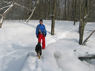
It seemed like a good opportunity to finalize the little bit I had left to get from Camp Ayapo / Perkins Mountain to Rattlesnake Hill. There were six or seven cars at the lot in Camp Ayapo at 11 a.m., which is nice to see. Folks are really enjoying the trails around the lake and along the ridge.
I took the "Yellow" trail out to where it turns to the "Red" trail, near Mulberry Lane. Ventured across the street and entered in along the old forest road that shows up on the topo map, which was what we used back in the day.
Rambled along and up, enjoyed the view east from the open edge of the ridge, and with a short drop down west I saw my footprints from yesterday. All set!
Explored a bit on the way back; interestingly I could occasionally spot the orange blazes of the old Boy Scout Path that covered from Minnechoag Mountain all the way through Pine and Rattlesnake, to Ayapo. I think this trail was set in the early 1980's?
Ended the day with 4.1-miles, it felt like more as it took me a while to fight through the snow.
View east off Rattlesnake Hill

Path through two boulders on extreme south end of Rattlesnake Hill

Top of Perkins Mountain

Old Bell at Camp Ayapo, Perkins and Rattlesnake in background

New sign / Kiosk at parking area at Camp Ayapo

Memorial Dedication Plaque on stone


Saturday, March 17, 2018
With the woods being in-between snowshoe and running shoe conditions, I figured I'd just head out to Skyline to attempt connecting to Rattlesnake Hill from Pine Mountain. This is the final piece of the old "Simons" runs, and thinking I'd be doing a lot of walking and hiking anyhow, exploring wouldn't be all that bad.
I made it over the Skyline Conservation Area just fine, crossed South Road, and headed east toward Pine. I knew from my visit on February 23rd that there was a trail heading south at the base of Pine.
Jumped three small deer, forcing them to climb up the steep south face of Pine Mountain, and then bent back due south from my northeast direction. Rambled on and it looked a bit familiar, and when I had a decision to head hard east uphill or stay more-or-less straight, I chose straight. As soon as I was a few minutes into this decision, and I turned west, I thought I remembered that turn from the old days. I lost a good amount of elevation, and didn't feel like turning back, and eventually I exited the woods into a large field with nearby homes.
I don't think this "new" development existed like this twenty or so years ago. I wandered through the cul-de-sac and found an old forest road that took me back to South Road, right across from the trail back up to Skyline. While climbing I jumped two more deer, so a great day for deer sightings.
Finished up with 5.8-miles, and a feeling of confidence regarding the last mile or two to get to Ayapo from Pine/Rattlesnake. The long-path is coming together.
Pine Mountain from the east-side of Skyline

Very large boulder close to the Skyline Peak

Additional boulder on the Yellow Trail


And, 15-years ago today, I explored the old Moody Spring course with Tippi. Nothing like a visit to Hawley and the Dubuque State Forest.
Gould Meadow Shelter

Tippi crossing the "pinebow snowbridge" we constructed for the race

Moody Spring

Tippi at the Basin Brook crossing

The Basin Brook Shelter

Bridge over Basin Brook, recently washed out by Hurricane Irene

Another view of the Basin Brook bridge

Friday, March 16, 2018
GOALS 2018 Update
My original list of twelve Williamsburg Woodland Trails to visit this year...
- Bradley
- Breckenridge
- Big View
- Briar Farm
- Graves Farm
- Hall / O'Neil
- Henhawk
- Historic Dam
- Petticoat Hill / Locke's Loop
- Tilton Farm (North & South), Goshen Open Space
- Lily Pond, Goshen
- Devils Den
I have been able to visit Bradley and Breckenridge, on February 19th & 24th. So, the one-per-month goal is working!


Bradley Sanctuary Kiosk

Breckenridge Sanctuary Kiosk

Thursday, March 15, 2018
3-mile run along the Metacomet from Phelps Road north. Snow remains on the trail, a few inches deep, for about half the route.
Looking off Nick's Hill

15-years ago today, March 15th, 2003, we held our 1st version of the Greylock Covered Bridge Snowshoe event. Figure 8 course, either 3.5 or 8-miles. 29 humans and 3 canine took it out and enjoyed the extended season.
Gotha in front of the one locked in grey...

BH with Sierra and Summitt

Wednesday, March 14, 2018


Tuesday, March 13, 2018
Monday, March 12, 2018


Sunday, March 11, 2018
I was able to travel a bit today, so I visited the Hitchcock Center for the Environment and participated in their "Nature All Year Study Club 2018", the first presentation of a planned 10 in 10 months.
Today's subject and presenter was Tree Identification: Bark, by Michael Wojtech. This was my first visit to Hitchcock Center, and it was valuable.

Once home, I was able to get in a 1-mile walk along the Bike Path in Southwick, figuring I would rest my left hamstring.
And, from old gps data, it looks as though Tippi and I continued to xplore Buckland snowmobile trails on this day (March 11th, 2007) ten-years ago.

And, from old gps data, it looks as though Tippi and I continued to xplore Buckland snowmobile trails on this day (March 11th, 2007) ten-years ago.

Saturday, March 10, 2018
Hit the road for an afternoon run, 5.2-miles on the Mather Loop. Feeling some tightness in my left hamstring, so it was slow-going. I am hoping to get back to the trails full-time, but with the snow and mud it is difficult right now.
I noticed while recording my miles that after today I am at 191.8-miles, with tomorrow still an option for this week. This week also happens to be the 10th week of the season for my calendar. My goal at week #10 was 192-miles, so I am right on track for the yearly goal I set of 1218-miles.
Expected mileage will pick up with daylight savings time and warmer temperatures coming in very soon. For the first 10-weeks, my mileage was only scheduled between 16 and 22 weekly miles.
Friday, March 9, 2018


Thursday, March 8, 2018
Decent snowstorm through last night, so I went to McLean to try snowshoeing. The snow was extremely wet, and the ground has been "soft", so snowshoeing was just ok, with a total of 3.8-miles total.
A view off Stony Hill, with the East and West Barndoor Hills in the distance


Cabin at Trout Pond


And, on this day in 2003 (fifteen long years ago), Moby Dick Snowshoe Race!
Pop and Tips

The Silverback, JC, MG, and K2

Gotha was with us that day; RIP Swanny... September 4th, 1949 - January 22, 2018

"Entering into Heaven is another awesome soul, my brother has gained his wings. He lived and enjoyed his life to the fullest, he was adventurous (extreme workouts, skiing, running many marathons), served his country (Navy), and always had a smile for everyone he met.
Although he maintained an extremely healthy lifestyle, like Muhammed Ali he was later stricken with Parkinson's. He was my big brother, he will be missed and also like Muhammed Ali: he in my heart will always be "The Greatest"" ~ Leslie Koonce
Wednesday, March 7, 2018
Music 2018...
Effort #10, Aldo's introduction to a Primitive's performance...

Effort #10, Aldo's introduction to a Primitive's performance...
Also, on this day in 2003 (15-years ago), our friend Paul joined Tippi and I to mark an 8-mile course (more or less) from the Visitor Center at the base of Mt. Greylock to Jones Nose and back.
Awesome weather by the looks of things, and an awesome time as I recall.
Crossing a bridge on the Northrup Trail

In the meadow below Jones Nose

Tuesday, March 6, 2018
On pavement again, at least it was a really nice day with sun and temperature in the 40's. Took the 7-mile Hill Street loop, nice and relaxing.
Later on, walked just under a mile on the Farmington Canal Greenway Trail, from Phelps Road over Mountain and Phelps Brooks.


Between the bridges for Phelps and Mountain Brooks along the Greenway

And, from old gps data, it looks as though Tippi and I begin to further explore Buckland snowmobile trails at this point, (February 29th & March 6th, 2007) ten-years ago.


Subscribe to:
Posts (Atom)