Thursday, June 30, 2016

On this day in 2006, I completed my 33rd marathon, Tunxis II.  This was the second time in 5-weeks that I marathoned along the Tunxis Trail...  this time, I used the southern portion down to Satan's Kingdom.  My time was 6:06:30, and I had Tippi along for company.  It was her 9th completed marathon.

Tippi on top of  Indian Council Caves, along the Tunxis.
 

Sunday, June 26, 2016

A very early start allowed me to get ahead of the sun, but it came with a price...  The deer flies were ferocious this morning.  

Grabbed the trail right at the Route 20, Newgate and Holcomb intersection and headed south toward Tarriffville.  Ended up with 10.2-miles in roughly 2:24:00.  

Biggest bummer today was the camera I had didn't want to work, so I missed out on some great pictures - which I hope to remedy soon.  There is a fantastic large Oak tree about 3/4-mile in from Route 20 that I've been passing by for over twenty years, and I don't think I have photographed it.  

Also, almost at the end of the Holcomb to Hatchet Hill Road section, there are two links to the past worth mentioning.  First, Charles Julian Kaiser's favorite outlook on the trail contains a footstone (which may mark Kaiser's ashes) with his name and dates of birth and death.  The stone reads "Charles Julian Kaiser, January 30, 1902 - October 9, 1952".  Secondly, I've noticed renovations to a 1770s era smallpox victim's graveyard just a half-mile or so from the road crossing.  Currently, it looks like three stones have been refurbished.  Very rewarding to see this effort being made.

Once across the street on the Tariffville section, I wandered off the Metacomet and explored Smaug's Lair and Egg Beater trails.  There is a network of routes to explore here, including Taj Mahal which I didn't get to.  

The map I am adding contains yesterday's section with today's.  Red is the Metacomet Trail, and the Yellow portions are Mountain Bike trails that veer off the main route (very nicely done, I have to add).

Hatchet Hill Peak.
 

Stone Chimney along Metacomet Trail.

Saturday, June 25, 2016

Something I do not do much of, a run in the later part of the day.  Didn't start out until close to 6:00 pm.  The conditions were comfortable, but I'll admit motivation is better when I run earlier...  

Metacomet from Hatchet Hill Road down to the Farmington River, and back.  There are many more "side-trails" available since I've last been here.  I don't know why I don't run this section more often, it's really nice.

Finished up with 3.8-miles total;  2.2-miles out to the Route 189 (I think) in Tariffville and with the short-cut coming back 1.6-miles.

View North, Upstream of the Farmington, from the lookout near T-Ville Gorge.

The Farmington River along the Metacomet Trail.


Friday, June 24, 2016

Took a run late along the Metacomet, from Phelps Road North.  Outstanding day to be anywhere, but especially the woods.  A nice 3-mile run to get my legs loose. Ended the day with playing some music.

Path uphill after power-line crossing.

Stone Marker at Trailhead, Hugh M. Alcorn Wildlife Preserve.

Today's Route, showing turn-around point.

Thursday, June 23, 2016

On this day in 2012, Wuzzam and I completed a Metacomet Marathon, with a time of 7:00:00.  Tippi ran the first section with us, from Route 20 to Phelps Road, and back (about 10.5-miles).  Weather report was that heating up was very possible - so the Donnalee grabbed Tippi early.  This was my 46th marathon completed.

Our Route for the Marathon Distance.

Tuesday, June 21, 2016

On this day in 1998, my Pop and I completed the 1st Greylock Centennial Marathon in Adams, Massachusetts.  Our time was 6:55:38.  This was a very difficult course, with 5 lengthy climbs.  The heat didn't help much either, if I remember correctly.

This was my 19th marathon completed, and my dad's first.

Sunday, June 19, 2016

On the trip to Adams to celebrate Father's Day, I detoured to Adams Road (Upper East Hoosac Street) in Savoy.  I wanted to check a snowmobile trail that would lead toward the old Marko Camp, above High Bridge and the Fritz Farm.

The Old Fritz Farm in 2003.

 View of Greylock from Fritz Farm, just above High Bridge.

The snowmobile path was short and not really necessary (there is the old road that acts as a driveway adjacent to the snowmobile path).  High Bridge was as awesome as always.  My last visit there was January 2003, with my dad and Paul.

High Bridge with Pop and Paul, January 2003.
 

This place really impresses me. The gorge and small falls are pretty awesome, right up with Windsor Jambs.  Out and back gave me 4.3-miles - I spent a bit of time looking for the "Lead Mine" but that will be for another day.

High Bridge in June 2016.

High Bridge in June 2016.

High Bridge in June 2016.


Saturday, June 18, 2016

As I have been adding completed marathons into this blog, I noticed that I haven't completed a "Tunxis" Marathon in a while.  Since June of 2012, to be precise.  Adding to that, I had once explored tying a route together from Granville State Forest just over the border in Massaschusetts, to join the Tunxis in East Hartland,  and then continue south to Satan's Kingdom - a one direction route pretty close to 26-miles.

Yesterday I checked on the Granville portion along Hubbard Brook.  Today I would explore Valley Brook and Hurricane Brook and complete the section from Granville State Forest to Route 20 on the Tunxis.

All went well, things are somewhat like I remember them.  Some logging has "opened" some narrow trails in Tunxis, and the old path along Valley Brook looks like repairs were made when logging took place.  Basic story is the route is still possible, and I have it mapped and measured.

Granville along Hubbard Brook to Route 20 at North Hollow measured up at 2.9-miles.  The section around Valley Brook, climbing to join the Tunxis Trail at Hurricane Brook, and continuing to Route 20 measured out at 6.1 -miles.  Both these sections lacked switchbacks and turns, so I believe the gps measurement is very accurate.  This leaves the northern route of the marathon plan right at 9.0-miles.

Excellent run, I ended up with 8.5-miles once back at the car.  Had not one, but two, close up encounters with Brother Bear (two separate individuals).  Big healthy creatures that didn't even give me the time of day (thankfully).

Trillum Hill is just over a 1/2-mile from the Route 20 parking area.

Northside of  Trillum Hill is home to Mountain Laurel.

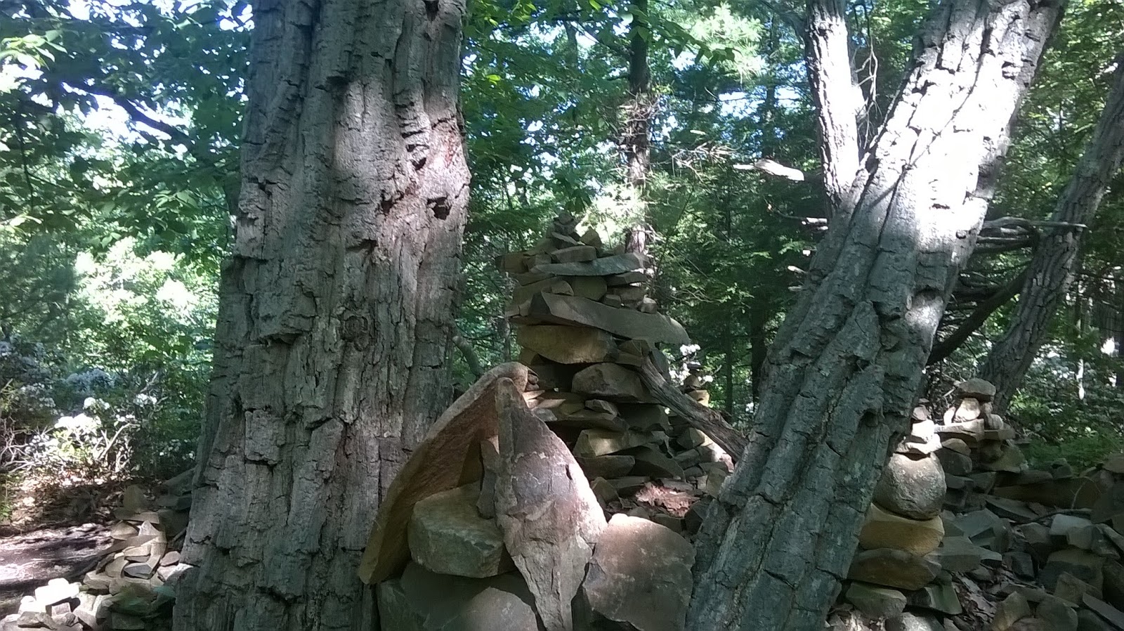
Stonework along upper Hurricane Brook.

 Connecticut and Massachusetts marker just off trail.

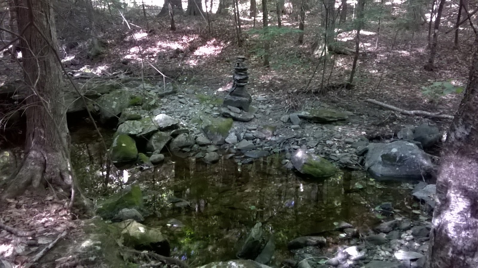
 The crossing at Valley Brook.

About 50' upstream at Valley Brook crossing, Brother Bear is passing through.

Today's 6.1-Mile route.

The planned northern section of the 2016 Tunxis Marathon.

Friday, June 17, 2016

Late start, not 100%, all the normal excuses.  Took some time working on old routes and maps, thought about the link from Granville State Forest to the Tunxis Trail.  That would be the goal today, to see if the Hubbard Brook Trail still would get me to Route 20.

Everything was in order, some of the old side routes look rough though, and there were no blazes at all on the Hubbard Brook Trail.  The swimming hole at the falls is posted no swimming.  Glad I was able to enjoy that when I did, a decade or more ago.

From the MDC parking at Route 20 to the gate at the bridge measured 2.9-miles.  I goofed off on side routes going back and ended with 6.3-miles total.  Hubbard Brook looked fascinating.

Hubbard Brook Cascades.

Hubbard Brook Cascades.

Hubbard Brook Small Falls.

Result of Nurse Log? 

The Old Swimming Hole and Falls.

More Nurse Log & Rock Joining.

Tuesday, June 14, 2016

Another trip along the Metacomet in West Suffield, Connecticut.  3.5-miles along the traprock ridge.

Spencer Woods Wildlife  Preserve, intersection of Phelps & Mountain Roads.

 Deep furrowed bark...

View to the Quarry, or Manitook Mountain, in Granby, CT.  


 I noticed this roadside memorial a while ago;  Mountain Road - Route 168.


Sunday, June 12, 2016


A big breezy day was forecast, I wanted to enjoy some woods-time.  Penwood is close enough, and rugged enough, to satisfy me today (and, allow a nice ninety minute loop to keep me on target time-wise).

I went out from Wintonbury Road again, it's out of the sun and busy enough with other park visitors that worries are minimal.  Interestingly, when I finished my 6.5-miles, I learned that a group of boy-scouts were in the first leg of an "adventure" race behind me, on the orange trail, riding mountain bikes.  Evidently, they mountain bike, run to the sycamore (I think), canoe down the Farmington River, and maybe one additional thing.  That is a pretty good adventure for young men 12 - 18 years old.

Penwood was nice;  this was my second visit this season, and the reminders of what a rewarding experience I had as a ridge runner here were many.

The Mountain Laurel ( Kalmia Latifolia) was in bloom, and it was worth the trip.  Located on the Blue-Blazed Metacomet (NET, New England Trail) about 1-mile north of the main parking area at Gale Pond.

The view from the Pinnacle, looking south to Hueblin Tower.

There is an incredible 1/8-mile or so of Mountain Laurel worth checking each May & June.

Blooming Mountain Laurel.

Mountain Laurel.

Mountain Laurel.

People have been stacking and shaping for a long while.
Effigy Site.

Close up.

Another.

Leading out, more Mountain Laurel.