
Friday, May 31, 2019
Thursday, May 30, 2019
Wednesday, May 29, 2019
Tuesday, May 28, 2019
On this day in 1995 I completed my 6th marathon, Vermont City. I had trained for a year specifically to run sub 3:10 at a marathon, so that I would qualify and gain entry into the 100th running of the Boston Marathon.
I recall feeling awful for the first couple miles, and beat from around 10 - 13 miles. At some point, my training kicked in, despite the heat, and I finished in 3:08. Qualified for Boston!
Monday, May 27, 2019
Nice run on a beautiful morning at Shenipsit State Forest with Wuzzam and the Old Goat.
We got 'round for 7.9-miles, with climbs up:
- Balanced Rock Hill
- Bent Birch Hill
- Three Rock Alignment Climb
- The Pinnacle
- Bald Mountain
Wuzzam and the Old Goat, pre-start & looking too happy

Wuzzam completing our last climb of the morning, Bald Mt


Sunday, May 26, 2019


Saturday, May 25, 2019
Still piecing the Granville & Tunxis Marathon distances together, so today I wanted to verify the section from Old Route 20 (Maybe called Walnut Hill?) to Route 219. This has always been thought of as 8-miles, and I am sure that I've verified this many times in the past, but once more wouldn't hurt.
Everything worked exactly as it seemed, distances were true to the Connecticut Walk Book and my prior notes. The turn-a-round at Route 219 had 7.95-miles on the gps.
A few alternate paths were chosen for the return trip, and I ended with 15.2-miles for the day.
During the evening, DL and I visited Gateway City Arts in Holyoke to hear the band X, which has been a favorite of ours for over 30-years. Taking the event up a notch, our old friend RunSteveo was attending also - someone we hadn't seen in many years.
The band played fantastically, and the venue was great (capacity of around 500, which was full).
It was great to see Steveo, and as far as the venue at Gateway City Arts, we'd visit again.
Large Boulder along the Tunxis Trail

Roberts Brook

Summit of Pine Mountain

Roaring Brook Upstream

Roaring Brook Downstream

Summit Indian Council Caves

Liddy, Tippi and Sam's Pool


Friday, May 24, 2019
Thursday, May 23, 2019
Five minutes into my run along the Metacomet Trail, from Phelps Road north, I was hit with a downpour. Within 15-minutes of the rain starting it was over, and I was pretty soaked. Ended up with the planned 3-miles.

Also, on this day in 2006, I completed a Tunxis Marathon in 5:41:50. I had Johnny Bandit along for company, as well as Tippi. It would be my 32nd marathon completed, and Tippi's 8th.
Lady Slippers along the Metacomet Trail

Also, on this day in 2006, I completed a Tunxis Marathon in 5:41:50. I had Johnny Bandit along for company, as well as Tippi. It would be my 32nd marathon completed, and Tippi's 8th.
John Bandit rambling through the meadow

We rambled from Route 20 to Route 219 in East Hartland, Connecticut,
and back for the first 19.5 miles. We finished up with the Route 20 to
Pell Road near the Massachusetts border for the final 6.5-miles.
Small Waterfall on the northern section of Tunxis Trail

Old Notes: Another great day; started out 45 degrees at the 9:15 A.M. start time. It reached a high of maybe 60 degrees during the day, with majority in the mid 50’s. Sunny and blue sky entire time, occasional strong breeze every once and a while. Started the run at 9:15 A.M.
Tippi taking a look down from the climb a mile from Pell Road

John and I both felt that it was the easiest marathon either of us had ever done. We finished strong, running all but the very start of Trillium Hill from mile 24.5 onward. I believe we could have easily gotten thru another hour on this day. Plenty of water for Tippi, no problems with her other than the porcupine around mile 18. We escaped from that ok.
The Pell Road TurnAround

Wednesday, May 22, 2019


Tuesday, May 21, 2019
Cowles Park in East Granby for 3.3-mile loop up to the Metacomet Ridge.

Stone Bridge Work

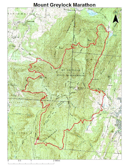
Additionally, on this day in 2005, I completed my 26th marathon (and Tippi's 2nd) at the Mount Greyklock Marathon '05 version {AKA Molitori 50th Birthday Bash & Annual Celibacy Run}.
Total time of 6:47:02. Five out of twelve starters completed the full 26.2-miles.
Monday, May 20, 2019
Sunday, May 19, 2019
Back to Tunxis with K2 to verify the next segment of our proposed marathon, Route 20 to Old Route 20 crossing. We managed a late start (compared to our normal routine), and it was fairly warm and humid at 2:30 p.m. when we began.
The woods were still a bit wet, as it rained again last night. The trail was in decent condition regardless, and the section measured out at 1.8-miles one-way. (Verification of Section 05 of the Granville to Satan's Kingdom Marathon from Route 20 to Old Route 20 at 1.8-miles.) This was regardless of the bad-weather bypass over the bridge, or the initial options just off Route 20. Whichever option we choose, this section will run us 1.8-miles.
Nice easy run of 3.6-miles, which was enough to keep my legs from becoming too stiff after yesterday's lengthy effort.
Nice easy run of 3.6-miles, which was enough to keep my legs from becoming too stiff after yesterday's lengthy effort.
Balanced Rock just off the Tunxis Trail

Balanced Rock just off the Tunxis Trail, another view

Balanced Rock just off the Tunxis Trail, another view

Balanced Rock just off the Tunxis Trail, another view

Morey Brook, a true favorite of mine

Stone Steps on the Tunxis Trail leading down Morey Brook


Saturday, May 18, 2019
It was going to be a fantastic day to be outdoors, and I needed a long-run. I also have been thinking about the Granville State Forest to Satan's Kingdom Marathon route I figured out a couple years ago (or so). I figured this would be an ideal day to verify distance of the first leg, which runs from Granville State Forest in Granville, Massachusetts to the Route 20 crossing on the Tunxis Trail in Hartland, Connecticut.
Section 01 would be from the Granville Forest parking area following the Hubbard River Trail down to North Hollow on Route 20 for 2.9-miles. This is a very scenic section, especially along the dozens of cascades on the Hubbard River. The section is basically downhill as well, so a nice lead in to a long day.
Section 02 carried me around the Valley Brook section, with a reverse of direction at Black Bear Crossing, total distance of 3.6-miles for this section, and a total distance of 6.5-miles. When I first explored this area, the path's were just old, soft dirt roads with grass growing in the center and edges. The last 15 or so years has been rough due to logging operations, and much stone has been placed on the old dirt. The canopy is missing as well, so the sun leaks through easily, so early morning is the best time of day (or later just before night).
Section 03 is a climb up the old jeep trail turned into logging area running just north of Hurricane Brook, meeting up with the Tunxis Trail at the lean-to shelter, and continuing to Hurricane Brook Road before the Trillum Hill climb. 1.2-miles for this slow section, with a total for the day of 7.7-miles.
Section 04, and my last of the day for the marathon route, is the major climb along the Tunxis up to Trillum Hill and then down to Route 20, a 1.3-mile section with half of it being steep, slow, uphill. The stop at Route 20 checked right at 9.0-miles - same as my old notes mentioned.
From here I took the jeep-path around the State Garage, to Hurricane Brook Road, and followed all the way back down to Route 20 again. This was on dirt and paved (believe it or not) forest road for almost 2-miles. Hurricane Brook has many wonderful cascades as well, not as "big" as Hubbard Brook, but really nice as well. This section is nicely shaded, and pretty much all downhill.
There is one area along Hurricane Brook with a small waterfall/cascade and a nice swimming hole below it. In the old days, Liddy, Tippi and Sam enjoyed cooling off within that wonderment.
Out to Route 20, ran along the shoulder for just under a mile to get me back to North Hollow parking area at 11.71-miles, and all that was left was the 3-miles back up along the Hubbard River Trail. Ended it up with 14.7-miles in 3:08 (4.7 mph average). A very satisfying run.
Monument to Milo B, Coe

Black Bear Crossing at Valley Brook

Feeder Stream to Hurricane Brook on the Tunxis Trail

Feeder Stream to Hurricane Brook on the Tunxis Trail

Trillum Hill, Tunxis Trail
Gorge on Hurricane Brook

Cascade on Hubbard River

Cascade on Hubbard River


Subscribe to:
Posts (Atom)