Sunday, May 27, 2018

Back to Cahokia to climb Monks Mound and explore the Woodhenge.  

The climb to the top of Monks Mound is split into two levels, with a flat "platform" between.  The location seems to be very popular with people training up and down, repetitively.  The views across the Grand Plaza toward the Twin Mounds is very impressive, early morning would most likely be fantastic.

The feeling I had while on top was special, as all four cardinal directions were open to me.  The Gateway Arch in St. Louis was easily in view.  Fascinating location and the work that went into constructing this landmark made an impression on us.

After about an hour on Monks Mound, we moved over to the Woodhenge, which is aligned with solstice and equinox calendar dates.  Again, amazing site.

Ended the day with some time inside the interpretive center, and gift shop purchases.  I enjoyed the visit so much, and being present at the location will help as I read through the books I have on Cahokia.  I definitely plan on another visit within the year.

Monks Mound

JC & DL starting the climb up Monks Mound

Across the Grand Plaza at Twin Mounds, from Monks Mound

From Monks Mound toward the Stockade

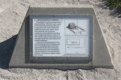
Monks Mound signage

JC Atop Monks Mound, with St. Louis in the background (including arch)

Top stairway going down off Monks Mound

Steps up Monks Mound

Monks Mound

Monks Mound signage

Monks Mound

Monks Mound

Woodhenge

Woodhenge signage

JC walking around the Woodhenge

More Woodhenge

Cahokia signage

Art on Interpretive Center doorway

Birdman Tablet at Cahokia

Saturday, May 26, 2018

Drove from Wheaton, IL to Cahokia Mounds State Historic Site & World Heritage Site in Collinsville, Illinois today with DL and JC.   It is a site I wished to see for the last couple years, and once there I was impressed with every detail.

We took a couple hours in the Interpretive Center, including the film presentation "Cahokia:  City of the Sun".   The time inside was informative, and amazing.

Once outside, we focused on a walk that would include The Twin Mounds (no.'s 59 & 60), Mound #56, and also the location of Mound #55.  We also passed through a view that extended over the Grand Plaza toward Monks Mound.

Some information on the Grand Plaza is as follows (from wikipedia):

To the south of Monks Mound is the Grand Plaza, a large area that covered roughly 50 acres and measured over 1,600 ft in length by over 900 ft in width. 

Researchers originally thought the flat, open terrain in this area reflected Cahokia's location on the Mississippi's alluvial flood plain, but instead soil studies have shown that the landscape was originally undulating ridge and swale topography. 

In one of the earliest large-scale construction projects, the site had been expertly and deliberately leveled and filled by the city's inhabitants. It is part of the sophisticated engineering displayed throughout the site. 

It was used for large ceremonies and gatherings, as well as for ritual games, such as chunkey. The game was played by rolling a disc-shaped chunky stone across the field. The men would throw spears where they thought the chunky stone would land. The game required a great deal of judgment and aim.

After our visit at Cahokia, we drove just a few miles into St. Louis, past the Gateway Arch, to Pappy's Smokehouse, which was also a lot of fun (and the food was delicious).

Mound 55 with Monks Mound in the background

Monks Mound from the edge of the Grand Plaza

Marker for the Twin Mounds

Twin Mound #60

Twin Mound #59, with Twin Mound #60 in background

Twin Mound # 60

Across the Grand Plaza toward 100' tall Monks Mound

Monks Mound again

DL & JC at the Twin Mounds


Friday, May 25, 2018

Flying into Chicago today to visit JC.  We have a trip to Cahokia planned for Saturday & Sunday.

Meanwhile, the Woods Walker's flyer for Farmington is below, "Rock Show" 2018 continues with presentation #4!


Thursday, May 24, 2018

Made it out early to Tunxis, to complete the Route 219 to Route 20 section.  On the way to stash water north of Pine Mountain, I was able to watch a young black bear cross the road and then stop to look at me.  Brother Bear (Br'er Bear), first sighting of the year for me.

Wuzzam met me for the run, we rambled out north from Route 219 and took the alternate dirt road options around Indian Council Caves and Pine Mountain for the "out" trip to Roberts Brook (our turn-around point on May 20th).  We managed the single-track trail sections on these two wonderfully magical locations for the trip back.

10.8-miles in sunny, mid 70-degree weather.  What a way to spend a Thursday.


Wuzzam at the Dog Pool

Looking east off Pine Mountain

Wuzzam pondering sites east off Pine Mountain

1st large boulder at the Indian Council Caves

A tiny Wuzzam climbing the caves

Looking north at the top of the Indian Council Caves

~10-miles of the Tunxis

Wednesday, May 23, 2018

Full morning of doctors for DL and PT for me.  The afternoon was flexible enough for me to roam around McLean Reservation again.  

I jogged past Spring Pond to look at some of the 140' white pine, which were amazing.  It is a little bit funny that I have been visiting McLean regularly since 1990, to enjoy the solitude and peacefulness of the white pine here, and to feel their height and presence, without knowing how tall these trees were.  Suddenly, very tall white pine have been measured to over 140' within this forest!

It was a slow run, which allowed me to notice a short, tall stonewall at the intersection of the North Trail and the forest road, just west of Kettle Pond.  I'll need to pay attention to this in the winter, and grab some photographs.

I worked my way up to the Eastern Barndoor Hill and enjoyed the climb, and the view.  Rambled on back to the car with 4.5-miles on my legs.

Looking at West Barndoor Hill from Eastern Barndoor Hill

Looking at West Barndoor Hill from Eastern Barndoor Hill

Looking northwest off Eastern Barndoor Hill


On this day in 2006, I completed a Tunxis Marathon in 5:41:50.  I had Johnny Bandit along for company, as well as Tippi.  It would be my 32nd marathon completed, and Tippi's 8th.

John Bandit rambling through the meadow.

We rambled from Route 20 to Route 219 in East Hartland, Connecticut, and back for the first 19.5 miles.  We finished up with the Route 20 to Pell Road near the Massachusetts border for the final 6.5-miles. 
Small Waterfall on the northern section of Tunxis Trail.

Old Notes:  Another great day;  started out 45 degrees at the 9:15 A.M. start time.  It reached a high of maybe 60 degrees during the day, with majority in the mid 50’s.  Sunny and blue sky entire time, occasional strong breeze every once and a while.  Started the run at 9:15 A.M.

Tippi taking a look down from the climb a mile from Pell Road.

John and I both felt that it was the easiest marathon either of us had ever done.  We finished strong, running all but the very start of Trillium Hill from mile 24.5 onward.  I believe we could have easily gotten thru another hour on this day.  Plenty of water for Tippi, no problems with her other than the porcupine around mile 18.  We escaped from that ok. 

 The Pell Road TurnAround.
  

Tuesday, May 22, 2018

Music 2018...

Effort #22, Stooges cover of "I Want To Be Your Dog", recently recorded one late night.  


Monday, May 21, 2018

An enjoyable 3.5-miles along the Metacomet north from Phelps Road.  It was a bit warm, but a decently blowing breeze made me smile.

Just past a mile out, after the peak

Ladyslipper are prevalent along the trail


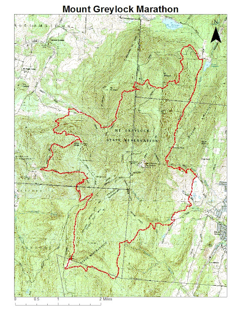
Additionally, on this day in 2005, I completed my 26th marathon (and Tippi's 2nd) at the Mount Greyklock Marathon '05 version {AKA Molitori 50th Birthday Bash & Annual Celibacy Run}.  Total time of 6:47:02.  Five out of twelve starters completed the full 26.2-miles.  

Sunday, May 20, 2018

Much better weather than Wuzzam, K2 or I had anticipated during our trip to Tunxis State Forest in East Hartland, Connecticut today.  A bit humid, but the rain held off and there was a nice, occasional cool breeze in the woods.

Wuzzam and I managed a comfortable 8-miles from Route 20 to Roberts Brook and back, with K2 doing slightly less.  The only real negative we came across was heavy logging, or planned forest thinning as the signs mentioned, between Pine Street and Sunset Road.  We didn't notice the old trail that connected off the main Tunxis to Roberts Brook, but at some point I'll check to see if it is still evident through the stumps and branches left behind.

On the way out, we took the bridge over the Cascade Brook, and on the return we crossed the water further downstream.  The many small falls and cascades that tumble down the brook are incredibly peaceful to observe.  Toward the top of the trail, there is a decently sized "pool" that our dogs always visited, regardless of temperature, in each direction of our run.  The memories we have of this location are endless, and welcome.  It is easy to visualize Liddy, Sam and Tippi bouncing around in there, until they finally just lay down and soak, waiting for us to continue.  Loop On you beast of the forest, I hope that I never forget the power of this spot.

On the way home, K2 and I took a small detour down Balance Rock Road to see which home the Balanced Rock lived in.  The large stone was visible from the road, and I'll get out there in the winter to shoot some photographs.

Unnamed Cascades

Balanced Rock at Cascades

Wuzzam at the Balanced Rock

Wuzzam at the Balanced Rock

Balanced Rock, another view

Cascades below Bridge

Cascades again

Wuzzam at Liddy, Sammy and Tippi's pool

Wuzzam at Liddy, Sammy and Tippi's pool

Upstream of the Dog's Pool