Excellent visit with my folks for the morning.
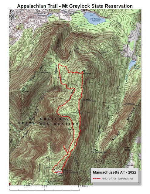
Having realized that I still needed to complete roughly the most northern 10-miles of Appalachian Trail in Massachusetts to finish another state off, and I haven't visited since November 18th last year due to tendon issues, I drove into North Adams and up Notch Road to Wilbur Clearing (elevation 2310') to start my AT Adventure 2022.
Great day, high 70's with not a ton of humidity. Bugs were at a minimum as well.
Down the road a bit from the parking area, and began climbing to Mt Williams (elevation 2951') right away. Didn't seem like 600' of climb so that was a bonus.
Continued on the AT south from Williams and intersected the 4-way with Bernard Farm Trail, great memories from the Greylock Marathon Training Runs and Events. Wonderful spot in a saddle.
Managed to summit Mt Fitch (3110') with a rough idea that I did, but I was unable to notice any signage. Not saying it wasn't there, but honestly I didn't see anything which was a shame.
Continued on and intersected with the Bellows Pipe Trail earlier than I thought, then the intersection with The Thunderbolt Ski Trail. Again, great multiple memories of these.
The section from the Thunderbolt intersection to meeting the Summit Road was longer than I had memory of. And it was in the direct sunlight and a decent climb. Alternately, the section from the road crossing up past the ski shelter and then the Memorial Tower at Greylock's Summit (3491') was shorter and easier than I remembered.
Took the upper Overlook Trail down to Notch Road, and the early portion was in much better shape than I recalled. The bottom nearing the road was as rocky and gnarly as I feared.
Figured I would run Notch Road back to the car, but took a bonus route to Robinson Lookout, which I had never explored in my life (hard to believe I avoided a trail on Greylock but there you have it).
The trail (Robinson Point Trail) is not very comfortable but the lookout with a beautiful wooden bench is worth the effort. I actually enjoyed going back out (uphill) more than the drop down to the Point.
Back on the road and to the car at Wilbur's Clearing went well, but the road does twist and turn a lot, adding distance.
Finished with 7.1-miles for the day, and I knocked 3.2-miles off my final 10.4-miles to complete the Massachusetts section of Appalachian Trail. This leaves me roughly 7.2-miles to the Vermont border.
Once back home, I took Lily for a 1-mile walk late at night.
View north from AT (Mt Fitch on left, Ragged Mountain to the right)
View from Robinson Point (Stony Ledge on left, Mt Prospect to the right)
View from Robinson Point (Mt Prospect on left, possibly Williams on right)
View from Robinson Point
View from Notch Road to the Greylock Summit


