3-miles along Main Street prior to work.
Tuesday, March 30, 2021
Yearly Running Miles Goal Update
Somehow, the year is a quarter over already...
March 28th was the end of the 13th week of the year 2021.
My mileage goal of 1350-miles in 2021 is on pace, whether I look at daily or weekly average.
Daily Miles needed to get to 1350 = 3.7-miles per day.
On March 28th, this would be a total of 321.9-miles, and I am at 378.2-miles (+56.3).
Weekly Miles needed to get to 1350 = 26-miles per week.
On March 28th, this totals 331.5-miles, and I am at 378.2-miles (+46.7).
Monday, March 29, 2021
Saturday, March 27, 2021
Friday, March 26, 2021
Thursday, March 25, 2021
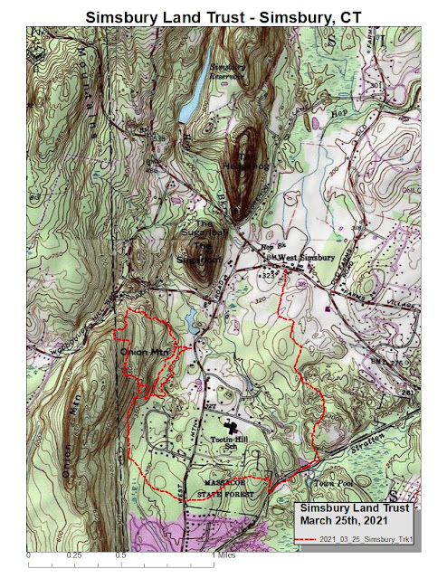
Visited a few properties in Simsbury Land Trust, namely Onion Mountain, Massacoe Forest, and Tulmeadow Farm Trail.
Managed to connect Onion (trails are in dire need of maintenance) to Massacoe (logging disturbance has made a complete mess out of the trailhead from Onion, and it appears that the "Friends of Massacoe" (or similar named entity) have managed to halt the destruction by DEEP Forest Management), connecting to the Tulmeadow Farm Trail (which was pretty awesome).
Ended the run with a section on the road to re-connect to the parking area at Onion Mountain, completed just over 6.4-miles for the day.
Wednesday, March 24, 2021
Tuesday, March 23, 2021
Monday, March 22, 2021
Sunday, March 21, 2021
Drove out to Ashfield to explore a few more of the snowmobile routes. I was hoping to find the trail from Beldingville Road, right on the Ashfield/Conway line, over the ravine between Mt Owen and Toby Hill. I covered this section on April 10, 2009 with Tippi. I haven't been back since.
I've been trying to cover all the snowmobile trails in Ashfield, with a late start of January 31st. This trail hadn't looked like it was being used, at least I couldn't see any sign of snowmobile traffic or activity at the Route 116 crossing.
As I started at the northern end, the snowmobile tracks I could still see in the snow bore left instead of the correct right at the top of the field. I followed this old logging path to the east of Toby Hill, until I was dropping down a steep ravine which would have brought me to Toby Hollow I suspect. Lesson of the day is to go with your first instinct, as mine was to travel right in the field rather than this dead-end of a left.
I decided to stay "higher" on the hill rather than totally retracing my steps, which would have meant losing a good bit of elevation I had gained. This was interesting, as there was a fairly "flat" game-trail along a contour that brought me along the north face of Toby Hill, until I intersected a path leading straight up a ravine along the west side of Toby Hill. This didn't look like a snowmobile trail (too steep), but I avoided my better judgement and explored.
I was making my way west, thinking that I would at some point find the correct trail, but I found myself on a ledge with a pretty severe drop, so I needed to travel north again to find a better re-entry point to the ravine which was housing the snowmobile corridor.
I finally managed to stumble onto the proper path, and followed it down to Route 116. It was pretty much as I remembered it, and doesn't look like it has changed much over the years I've been away from it. My guess of no snowmobile traffic looks likely, at least for this year if not a few years, as there were no tracks, and many downed trees along the way. Later on, when heading back towards my start point on Beldingville, the snowmobile corridor trail is marked "closed" for about a quarter-mile section. This explains why no sleds going through.
Finished with 7-miles, which included the exploring on the way north to south. I also ran some on the road toward Sabin and Pine Hill, seeing where the snowmobile trail went to the east.
The northern half of this range still held about a half to a full foot of snow, with the southern section bare ground. The footing was extremely difficult in the snow.


