Magnificent day, mid sixties and sunny. No humidity, No bugs, and No snakes! I felt decent, or at least better than I have been regarding leg discomfort. I planned on driving to Savoy, for three possible destinations....
First, to get back on the
Berkshire Natural Resources Council Hoosac Range Trail to Spruce Hill. I've written (March 22, 2017) of a Spruce Hill vision. This would be my first visit back since early in 2015 (very hard to believe, as I used to routinely make it to Spruce Hill monthly).
Second, I'd cross Route 2 above the Wigwam and Western Summit Gift Shop to head to "Top of the World", and then further north to Canyon Brook. Once at Canyon Brook, I would hope to venture downstream to potential waterfalls I had read about in "Wild Side Adventures" by Nan Williams.
Lastly, I have been doing some research on the Second Hathaway Cemetery, in Savoy. Middle of nowhere, no trail leading into it, sounded fun.
Things worked out pretty well. I covered 7.1-miles between the Hoosac Range and Top of the World.
The Hoosac Range Trail to Spruce Hill was in fantastic shape, the first couple miles recently weed-whacked even. This trail is easily in my top ten trails to explore, it's got climbing, views, and scenery. There is an old path leading east toward a large pond that I need to explore on my next visit.
Once back at the BNRC Kiosk, I continued across Route 2 and up the service road to the cell tower. The short run out to Top of the World, which I had last visited toward the end of May, 2015, was awesome. The image on the top right of this blog homepage is from that visit, with Tippi walking toward the edge. After the view, however, the trail developed into multiple, large mud-holes. It's obvious that it has been a rainy couple months. I decided to bail on the potential waterfalls (I imagine with this much water it would have been great) and head to Savoy Hollow on the Windsor border for a graveyard search. I'll be back for Canyon Brook and Falls soon enough, when things dry out just a bit.
To get to Savoy Hollow, I decided to check Black Brook Road. It looked "open" when I drove past this morning (the road was totaled and closed since Hurricane Irene). It is now open, and in great shape!
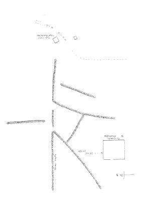
To find the Second Hathaway Cemetery, I plotted a "clear" area in ArcMap after downloading LiDar data for the area. The spot I picked looked right, and I thought I could see a stonewall around the clearing. To get there, I decided to make it fun, and memorize stonewalls that would lead basically to the graveyard. These stonewalls show up fantastically well in the data.
I found the Second Hathaway Lot, and it was really memorable. The only mix-up I had was one of the stonewalls I needed to follow stopped before it was supposed to (should have intersected with a east/west stonewall). This lead to me wandering a bit, and following a stonewall I "thought" was correct but I couldn't be sure. All worked out in the end, and I left the area a pretty happy visitor.
The search for the graves took about 2-miles of hiking. I exited along a snowmobile trail for some of it, and by the looks of the notes and the LiDar image, I walked right by a cellar hole I would have liked to have viewed. Looks like another visit will be necessary!
Berkshire Natural Resource Council's Hoosac Range Kiosk
View from Sunset Rock on the Hoosac Range Trail
Hollowed trunk along the trail
Two large quartzite
boulders on the trail
The Hoosac Tunnel passes underneath this location
View southeast, with Borden Mountain at the far left
Looking off Spruce Hill toward Greylock
Proof positive I am where I thought I was!
View north with both sets of windmills viewable
A side trail with a view of Greylock
Top of the World, looking at Greylock
Rough Location of the Second Hathaway Graveyard (green dot)
LiDar showing the stonewalls as raised surfaces (green dot still visible)
My route following the stonewalls and finally getting a little lucky!
The gate and stonewall surrounding the Second Hathaway Cemetery
Many graves are still standing
Welcome Stanton and L. Clarinda Stanton
Looking northeast toward the surrounding stonewall
Written data regarding the Second Hathaway Cemetery


