Friday, June 1, 2018

A little warm and just after the rain had fallen, the 3.7-miles along the Metacomet Trail south from Phelps Road was a welcome today.  It felt really good to enjoy the woods and loose my mind for a little bit of time.

The forest has really "greened up" since last week

Old News Department...

On this day in 1997 I completed my 14th marathon - Nipmuck.  It was the 3rd time I completed Nipmuck, and my time was 4:31:44, good enough for 42nd place.

Also, on this day in 2013, I completed my 49th marathon - Hawley Berkshire East.  I had Wuzzam with me for this one, which was a real beast.  We had a total time on feet of 7:45:15, which was the longest either of have ever been on our feet moving through the forest.  It was most likely more than a marathon distance.  By several miles...  (or more).


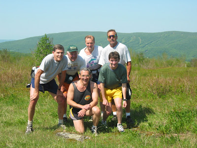
In the way-back department, from June 1st, 2002 (sixteen big years if you want me to do the math), a group of Adams-Boys and a few others tackled a long run on Greylock.  By the look of the pictures, I can recreate out steps... it was a longish day judging by the snapshots.

The Group at Jones Nose

Climbing Jones Nose

Rest Break after the climb

Billy leading us through CCC Dymanite Trail

Another Rest Break

Deer Hill Falls

A very young Trail Troll with Tippi

Thursday, May 31, 2018

Music 2018...

Effort #23, The Modern Lovers "Roadrunner" covered by the Primatives in 1984, the trio version (Farmer, Aldo, Lee) at "the Art Studio".

"...Don't Feel so Low with the Radio On."


Wednesday, May 30, 2018

On this day in 2009, Wuzzam and I completed a McClean Reservation Marathon in roughly five hours.   This was my 39th marathon completed.  I recall it being a fairly easy day for us.

Tuesday, May 29, 2018

After a nice breakfast with DL & Bonita (our dog friend), and some laundry, I hit the road to run the northern section of Tunxis Trail.

It was pretty warm, and humid, and the four days of no-running didn't really place me in a great spot.  I enjoyed the run north, out to the Massachusetts / Connecticut state line monument, but prior to the steep climb up towards Pell Road I thought about running the road back, just for a change.

The swampy section on-top has been improved with planking / bridgework, and the trail is in really great shape.  Actually, I've been on this section several dozen times over the years, and today was the most "easy-to-follow" I can recall.

Once at Pell Road, I headed south and passed the road heading east that drops down to Route 179 in North Granby.  A bit further along I saw an old path leading west, and decided to explore.  Luckily I did, as it was a really great connector to the Hurricane Brook Shelter along the Tunxis Trail.

Once back within throwing distance of the trail, I continued along Hurricane Brook Road back up to Route 20.  Lots of climb, just like the trail, with nice views of the stream on my right most of the way.

Managed 6.1-miles in the warmth of late May, and it was encouraging to piece together the "new" trail into my network.

Top of Trillium Hill

Hurricane Brook crossing

Hemlock and Rock 


Monday, May 28, 2018

Spent a reflective Memorial Day back in Wheaton, Illinois with JC & DL before flying back to Connecticut in the evening.  My current thought on flying, which I had done a lot of in the 1980's but have only made three recent trips (last two years), is that I enjoy driving much more.

It was a great small vacation, and I'll be back to Illinois and Cahokia.

Also, on this day in 1995 I completed my 6th marathon, Vermont City.  I had trained for a year specifically to run sub 3:10 at a marathon, so that I would qualify and gain entry into the 100th running of the Boston Marathon.

I recall feeling awful for the first couple miles, and beat from around  10 - 13 miles.  At some point, my training kicked in, despite the heat, and I finished in 3:08.  Qualified for Boston!

Sunday, May 27, 2018

Back to Cahokia to climb Monks Mound and explore the Woodhenge.  

The climb to the top of Monks Mound is split into two levels, with a flat "platform" between.  The location seems to be very popular with people training up and down, repetitively.  The views across the Grand Plaza toward the Twin Mounds is very impressive, early morning would most likely be fantastic.

The feeling I had while on top was special, as all four cardinal directions were open to me.  The Gateway Arch in St. Louis was easily in view.  Fascinating location and the work that went into constructing this landmark made an impression on us.

After about an hour on Monks Mound, we moved over to the Woodhenge, which is aligned with solstice and equinox calendar dates.  Again, amazing site.

Ended the day with some time inside the interpretive center, and gift shop purchases.  I enjoyed the visit so much, and being present at the location will help as I read through the books I have on Cahokia.  I definitely plan on another visit within the year.

Monks Mound

JC & DL starting the climb up Monks Mound

Across the Grand Plaza at Twin Mounds, from Monks Mound

From Monks Mound toward the Stockade

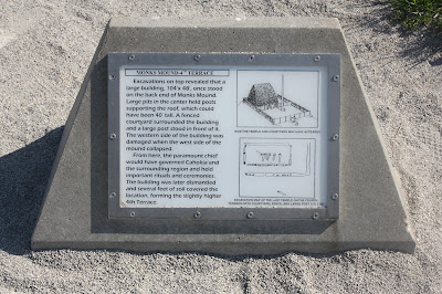
Monks Mound signage

JC Atop Monks Mound, with St. Louis in the background (including arch)

Top stairway going down off Monks Mound

Steps up Monks Mound

Monks Mound

Monks Mound signage

Monks Mound

Monks Mound

Woodhenge

Woodhenge signage

JC walking around the Woodhenge

More Woodhenge

Cahokia signage

Art on Interpretive Center doorway

Birdman Tablet at Cahokia

Saturday, May 26, 2018

Drove from Wheaton, IL to Cahokia Mounds State Historic Site & World Heritage Site in Collinsville, Illinois today with DL and JC.   It is a site I wished to see for the last couple years, and once there I was impressed with every detail.

We took a couple hours in the Interpretive Center, including the film presentation "Cahokia:  City of the Sun".   The time inside was informative, and amazing.

Once outside, we focused on a walk that would include The Twin Mounds (no.'s 59 & 60), Mound #56, and also the location of Mound #55.  We also passed through a view that extended over the Grand Plaza toward Monks Mound.

Some information on the Grand Plaza is as follows (from wikipedia):

To the south of Monks Mound is the Grand Plaza, a large area that covered roughly 50 acres and measured over 1,600 ft in length by over 900 ft in width. 

Researchers originally thought the flat, open terrain in this area reflected Cahokia's location on the Mississippi's alluvial flood plain, but instead soil studies have shown that the landscape was originally undulating ridge and swale topography. 

In one of the earliest large-scale construction projects, the site had been expertly and deliberately leveled and filled by the city's inhabitants. It is part of the sophisticated engineering displayed throughout the site. 

It was used for large ceremonies and gatherings, as well as for ritual games, such as chunkey. The game was played by rolling a disc-shaped chunky stone across the field. The men would throw spears where they thought the chunky stone would land. The game required a great deal of judgment and aim.

After our visit at Cahokia, we drove just a few miles into St. Louis, past the Gateway Arch, to Pappy's Smokehouse, which was also a lot of fun (and the food was delicious).

Mound 55 with Monks Mound in the background

Monks Mound from the edge of the Grand Plaza

Marker for the Twin Mounds

Twin Mound #60

Twin Mound #59, with Twin Mound #60 in background

Twin Mound # 60

Across the Grand Plaza toward 100' tall Monks Mound

Monks Mound again

DL & JC at the Twin Mounds


Friday, May 25, 2018

Flying into Chicago today to visit JC.  We have a trip to Cahokia planned for Saturday & Sunday.

Meanwhile, the Woods Walker's flyer for Farmington is below, "Rock Show" 2018 continues with presentation #4!


Thursday, May 24, 2018

Made it out early to Tunxis, to complete the Route 219 to Route 20 section.  On the way to stash water north of Pine Mountain, I was able to watch a young black bear cross the road and then stop to look at me.  Brother Bear (Br'er Bear), first sighting of the year for me.

Wuzzam met me for the run, we rambled out north from Route 219 and took the alternate dirt road options around Indian Council Caves and Pine Mountain for the "out" trip to Roberts Brook (our turn-around point on May 20th).  We managed the single-track trail sections on these two wonderfully magical locations for the trip back.

10.8-miles in sunny, mid 70-degree weather.  What a way to spend a Thursday.


Wuzzam at the Dog Pool

Looking east off Pine Mountain

Wuzzam pondering sites east off Pine Mountain

1st large boulder at the Indian Council Caves

A tiny Wuzzam climbing the caves

Looking north at the top of the Indian Council Caves

~10-miles of the Tunxis