Friday, August 7, 2020

Today I would finish the Connecticut Section of the Appalachian Trail.  I had roughly two unfinished miles, from Hoyt Road on the New York border to the top of Ten-Mile Hill, where I turned last weekend.

The damage from Tropical Storm Isaias was difficult to move through, luckily it wasn't continuous but intermittent.  Regardless, once I re-connected to last week's turn-a-round spot on Ten-Mile Hill, I continued to the Herrick Trail and Preserve, with the understanding that if the trails were a mess I would run back to the parking area on Route 55 via the road, which is what I ended up doing.

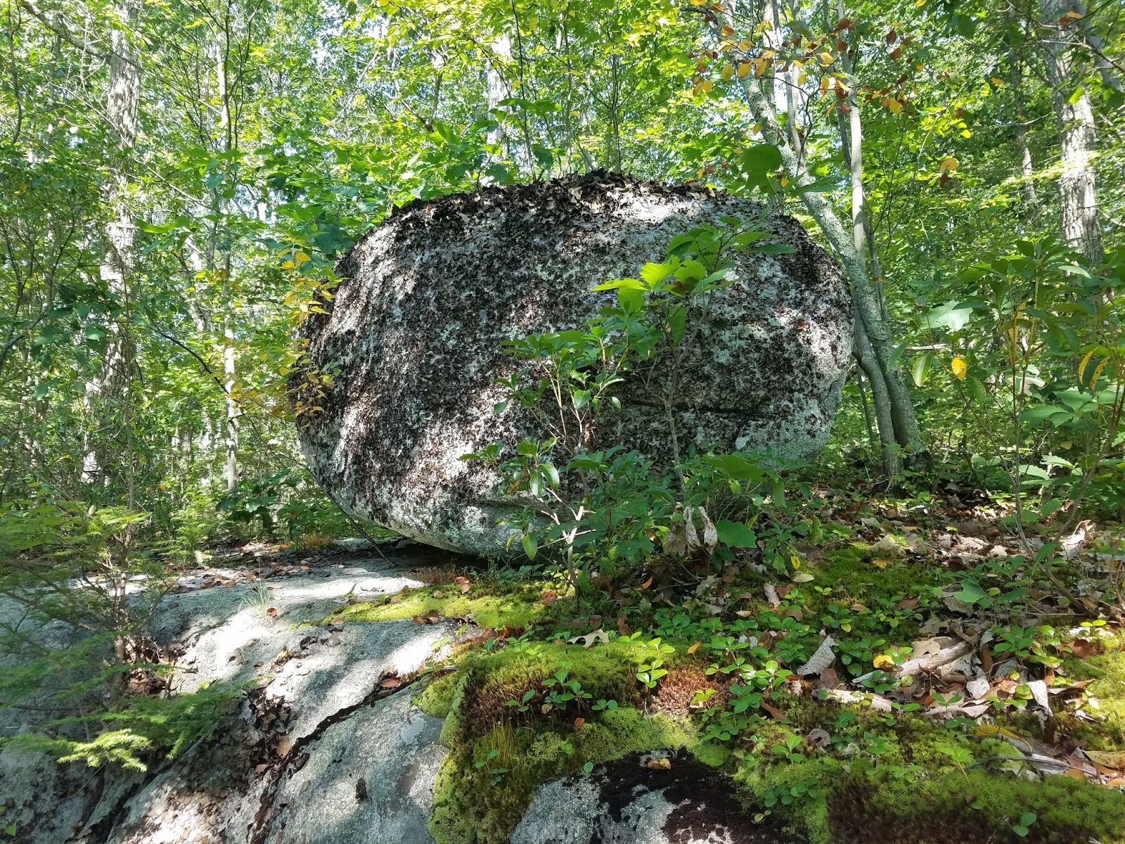
Finished with 5.5-miles, and very impressed with the Herrick Preserve.  Incredible stonewalls, one huge boulder, and the views from Housatonic Overlook and Amy's Overlook.

The completion of the Appalachian Trail in Connecticut is something worthwhile, the 56-miles (or so) were doubled as I had to cover out-and-backs each visit.  As I occasionally look at pictures of the trail on the web, I recognize each spot and the segment it is located.  I've added this knowledge to my circled world.

CT/NY Border Kiosk 

 Entering Connecticut

Housatonic Overlook in the Herrick Preserve

Housatonic Overlook in the Herrick Preserve

Amy's Overlook

Large Rock at Amy's Overlook

Amy's Overlook

Undulating Stonewall in Herrick Preserve

Entrance to Herrick Preserve

Roadside Memorial on Route 7 & Route 55

Thursday, August 6, 2020

Nice trip to visit the folks, once back home a easy 3-miles along Main Street.

Wednesday, August 5, 2020

Black Lizard / Vintage Crime #31 for 2020...

"Sideswipe", Charles Willeford's 1987 continuation to the Hoke Mosely's story.

Black Lizard Vintage Crime Cover


Alt Cover

Alt Cover

Alt Cover

Tuesday, August 4, 2020

Music 2020...

Effort #32,  "Gypsy"...  Nice mellow cover of Savoy Brown's opening track from their 1970's album "Looking In", as performed by RSC during early June 2020.


On a side-note, Tropical Storm Isaias hit us pretty hard with extreme wind causing severe damage throughout the afternoon and evening.

Monday, August 3, 2020

On this day... 

I completed my 13th marathon.  My route took me along the Appalachian Trail, from Salisbury, Connecticut into Massachusetts.  My turnaround point was at the summit of Mt. Everett.  My time on the trail was roughly 6:27:53, which included a break for a lunch at Everett.

Sunday, August 2, 2020

Ran along the Metacomet for 7.8-miles from Phelps Road to Peak/Copper Mountain on a warm Sunday morning.


Saturday, August 1, 2020

I am grinding away at completing the Connecticut Section of the Appalachian Trail, with only 6 to 7-miles remaining to finish.

Up early, as we are dog-sitting "Bonita", and DL and I walked the little animal around town at 5:00 a.m.  We had an outstanding breakfast of pancakes and bacon, and I hit the road returning to Kent, Connecticut at 6:30 a.m.

Parked along Schaghticoke Road very close to where the AT turns back into the woods off the dirt road.  Slowly climbed back to the majestic Schaghticoke Mountain Overlook which was my turn-around-point during last visit to the AT, and turned again at 1.6-miles.

Back down toward Schaghticoke Road at 3.1-miles, and jogged the road to re-enter the woods within a half-mile or so.  Beginning ramble kept the Housatonic River in view, before crossing the convergence of the Ten Mile River and the Housatonic on the 120' Ned Anderson Memorial Bridge.  This bridge was constructed in 1983 and is named after a local farmer who also designed, built and maintained the original AT in Connecticut.

A bit more nice running along the Ten Mile Brook before turning to climb Ten Mile Hill, elevation 1000'.  Saw the Catskills from the top, which would be my point to retrace my steps back to the car on Schaghticoke Road.  Finished the day with 8.8-miles, and only two unfinished miles to complete the Connecticut Section of the Appalachian Trail (Ten Mile Hill to Hoyt Road).

View from Schaghticoke Mountain Overlook

View from Schaghticoke Mountain Overlook

View from Schaghticoke Mountain Overlook

View from Schaghticoke Mountain Overlook

View from Schaghticoke Road of the Overlook

Housatonic River

120' Ned Anderson Memorial Bridge

View toward the Housatonic from the Ned Anderson Bridge

View toward the Ten Mile River from the Ned Anderson Bridge

View from the Ned Anderson Memorial Bridge

View north-west from Ten Mile Hill

Summit of Ten Mile Hill

Friday, July 31, 2020

"High Points" along the trails I've visited during July. 2020.
  • Barrack Matiff Plateau, Appalachian Trail
  • Billy's View, Appalachian Trail
  • Giants Thumb, Appalachian Trail
  • Rand's View, Appalachian Trail
  • Limestone Spring Gorge, Appalachian Trail
  • Pinnacle, Metacomet Trail (NET), Penwood State Park, CT
  • Nick's Hill, Metacomet Trail, West Suffield, CT
  • West Suffield Mountain, Metacomet Trail, West Suffield, CT
  • Copper/Peak Mountain, Metacomet Trail, Granby, CT
  • Silver Hill, Appalachian Trail
  • Fuller Mountain, Appalachian Trail
  • Caleb's Peak, Appalachian Trail
  • St. John Ledges, Appalachian Trail
  • Schaghticoke Mountain Overlook, Appalachian Trail
  • Mt Algo, Appalachian Trail
  • Indian Rock, Appalachian Trail

Thursday, July 30, 2020

5.5-mile run into work between 6:00 a.m. and 7:00 a.m.

Wednesday, July 29, 2020

3.9-miles along Main Street early morning.

Tuesday, July 28, 2020

On this day in 2005...

Tippi and I ran the Savoy General Store Marathon.  It was lengthy, over 29-miles I believe.  From Haskins Road to the General Store, which brought us all the way over to Windsor Jambs, we had the company of "Max", a friendly dog we picked up at Loop & Haskins intersection. 

Tippi along the trails of Savoy, 2005.

Oddly, each time we came to an intersection on the trail, "Max" knew which way we were planning on turning (even though he lead).  He managed this for 9 - 10 miles.

Total for the day was roughly 29.30-miles in 6:17:52.  It was my 29th completed marathon, and Tippi's 3rd.  After finishing, I met Jane Phinney in the Savoy Town Offices;  she was the Savoy Town Clerk and is the author of  "Taking the High Road". 


Monday, July 27, 2020

Music 2020...

Effort #31,  "Cleansing Spirits of Heaviness"...  seventh and final mind-melting exploration from the Dark Heart Duo's Cleansing Spirits Session, recorded September 6th, 2019.


Sunday, July 26, 2020

A hot 3.9-miles along Main Street during mid-morning.

Saturday, July 25, 2020

When the day began, all I had left of the Connecticut Section of the Appalachian Trail is south from Route 341 in Kent to Hoyt Road in Sherman.  This, according to the Connecticut Walk Book, measures out at 12.7-miles.  Other sources call it slightly less.

I set off as early as I could, as it was to be a very hot one again today.  I hoped to run for 5 or 6-miles, before turning back for my out and back.

It was already warm, and humid at my start.  The climb up Mt Algo all the way to Indian Rock in the Schaghticoke Tribal Nation, roughly 3-miles, was a chore.

Speaking of the Schaghticoke's, a little research reveals:


After a series of many up's and down's, and the presence of many balanced / perched rocks along the route, I finally encountered a "runnable" section that opened to a majestic overlook (Schaghticoke Mountain Overlook) to the south at 5.75-miles.  A great spot to turnaround.

Along the way back, I managed to take a fall, hitting my head on a branch and "...knocked the tar out me" as my friend Paul H used to say.  It was also really hot by this point, and the climbs were crushers today.  I managed to push through the final 3.5-miles or so, but it wasn't pretty.

Ended the day with 11.6-miles, and despite the difficulty I had (mostly due to the heat, I believe), I would like to re-visit this section of the Appalachian Trail.  I captured many balanced rocks in photographs, but on the return I believe I noticed a few more slightly off the trail.  These are worth documenting.

There were many views, and Thayer Brook was running with some water...  during a "wetter" year I imagine this would be a beautiful stream.

AT Path between rocks, 1-mile out from Rt 341

First View of the Day off Algo, roughly 2-miles from 341

View off Mt Algo, roughly 2.5-miles from 341

Indian Rock, roughly 3-miles in from 341

Indian Rock

Indian Rock

Indian Rock

View within the Schaghticoke Reservation

Balanced Rock on Schaghticoke Mountain

Balanced Rock on Schaghticoke Mountain

Another Balanced Rock on Schaghticoke Mountain

Balanced Rock on Schaghticoke Mountain

View south from Schaghticoke Mountain

View south from Schaghticoke Mountain

View south from Schaghticoke Mountain

View south from Schaghticoke Mountain

View south from Schaghticoke Mountain

Heading back toward Mt Algo