Friday, February 12, 2021

3-miles along North Main Street just prior to dark. 

Thursday, February 11, 2021

Another day tying up the snowmobile corridor network in Ashfield.  

This time, began at the Post Office, up the steep climb to briefly join my route from Saturday, and choose the split heading back south in the woods adjacent to the golf course.  From here, I wished to follow the trail down to the Route 116 crossing at Emmets Road, climb up towards Mill Hill, and end at Beldingville.

When I reached the power lines, I turned back and completed the day with 7.7-miles.

Wednesday, February 10, 2021

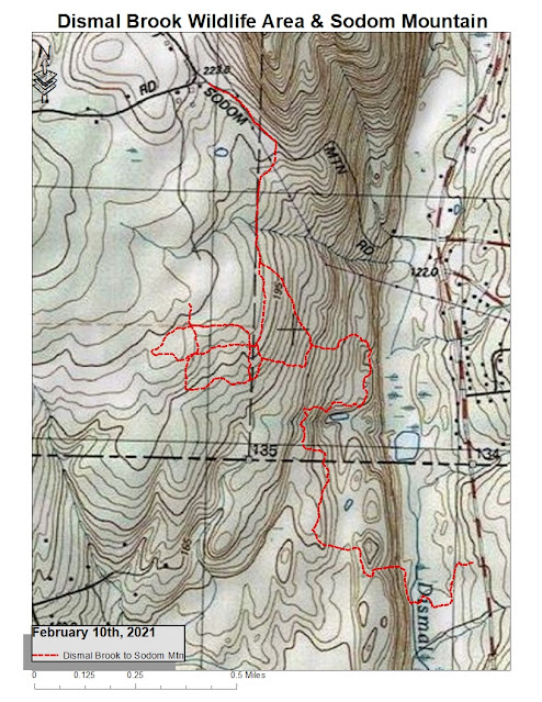
Late afternoon visit to the Dismal Brook Wildlife Area in Granby.  Snowshoe'd a bit of obscure path, and then some wider options, some of which had been snowmobiled.

Made my way out to Sodom Mountain Road, at the southern end of Sodom Mountain, it looks like.  Tallied up 7-miles for the day.

Tuesday, February 9, 2021

3-miles on North Main as the snow was ending.

Monday, February 8, 2021

Another visit to Ashfield to continue with the snowmobile corridor connections.

This time, I would hopefully complete the loop from my ending point on Saturday, near the Ashfield Bear Den, and continue out to Bear Swamp Road and fill in the gap to Watson-Spruce Corner Road.

All was successful, finished with 6.85-miles and feeling good.

And, in the Old News Department...  one year ago today:

Nipmuck - Natchaug Marathon - February 8th, 2020
Ashford, Union,  & Eastford, CT
.
I met up with Andy Hillbilliage early to attempt a Nipmuck / Natchaug Marathon.  The Wuzzam was planning to meet up with us to ramble through the last 9 or 10-miles with us, as his legs were still feeling last weekend's 17-miler.

The route is fairly easy:
  • Boston Hollow Road, Ashford, north on Nipmuck Trail to Bigelow Hollow (~8-miles).
  • Return via the same route, opposite direction (~8-miles).
  • South from Boston Hollow along the Nipmuck Trail to the turn onto the Natchaug Trail just prior to Ladies Room Rock, down to Moon Road (~4.5-miles).
  • And then return along the same sections (~4.5-miles).
What isn't easy is the trail really rolls up and down.  A lot.  5760' of ascent and descent for the full gps measured 24.6-miles.  It was also somewhat cold (around 22-degrees at the start), but that didn't stop Hillbilliage from going with shorts and a short-sleeve top for the last 9+ miles (where it might have gotten to 32-degrees or so, outside the Hemlock forest).

We completed what we wanted, pretty much averaging 4.1 mph the entire day.  At 2-miles we were at 4.3 mph, at 8 the same, at 16 the same, at 20.5 we dropped to 4.2 mph, which we almost maintained to the end.  Very steady rolling.

Completed in 6:01:00, which I felt pretty good about.  It was really awesome of Wuzzam to meet up with us to help with the company, that I (we) really appreciated, as Andy and I were getting a bit tired by the last sections.  Great day, outstanding mileage builder!

This was my 58th completed marathon all-time.

Sunday, February 7, 2021

3.4-miles on the Main-Kent-Wisteria-Bridge Street loop just as the snow began to fall.

Saturday, February 6, 2021

Ashfield to develop my journey along the snowmobile routes.  I've been rekindled regarding these trails, and it's been too long since I connected them together.

Spent 13.7-miles on my feet, with over 11 of them on snowshoes.  I finally took them off once I intersected Bug Hill Road, for the last bit navigating back to Dyer Road.

Friday, February 5, 2021

Finally made it out for an actual run this week, early morning along Main Street for 3-miles.

Thursday, February 4, 2021

 What played in Ed’s Head, January 2021

{a list of the complete albums I listened to during this time}


Wednesday, February 3, 2021

"High Points" along the trails I've visited during January, 2021.
  • Nick's Hill, Metacomet Ridge, West Suffield, CT
  • Hart's Pond Hill, Metacomet Ridge, Agawam, MA
  • Stony Hill, McLean - Holcomb, Granby, CT
  • Crag Mountain, Granby, CT
  • Mary Edward Mountain Property, Granby, CT
  • East & West Saddleback, Mary Edwards Mountain Property, Granby, CT
  • Hatchet Hill, Metacomet Ridge, East Granby, CT
  • Marsh Pond Hill, Metacomet Ridge, East Granby, CT
  • The "Wall", Tunxis Trail System, Burlington, CT
  • Manitook Mountain, West Suffield, CT
  • Westledge Hill, McLean Game Refuge, Granby/Simsbury, CT
  • West Mountain, Simsbury, CT

Tuesday, February 2, 2021

Music 2021...

Effort #05,  "Overcome Evil with Good"...  final recording from Eve of Destruction.

Recorded in the basement studio, solo.  


Monday, February 1, 2021

On this day in 1998, the 4th Annual Moby Dick Marathons were held over Greylock. I completed my 19th marathon in 6:19:40, with Johnny Bandit.  It was the second time I wore snowshoes for the 28-mile adventure.  It would be the last time I would snowshoe this distance!

Overlooking Ragged Mountain

Memorial Tower

Sunday, January 31, 2021

Traveled out to Farmer Tom's to record some gps data, assisting with a map update.  Completed 2.7-miles of snowshoeing in a foot of unbroken powder, with fantastic company.

Once completed, I drove just a few moments to park at a snowmobile crossing, and snowshoed out past Peppermint Park, for an additional 3-miles of snowshoeing, before taking the 'shoes off to run the remaining 3-miles back.

Ended the day with 8.7-miles in twenty degrees with beautiful sunlight. 


Saturday, January 30, 2021

I finally stopped at the Swan Preserve in Canton, right near the Canton/Granby/Simsbury border.

I have been passing by this little area each time I have driven out to Burlington to explore the Tunxis, and I kept thinking "... one of these days, I'll see how close these trails get to McLean's West Ledge Trail".

The map at the Kiosk, as well as the online available information, showed Red, Yellow and Blue Trails, with a bit of a possible extended trail to the west.  This would be the one I hoped would get me close to West Ledge.

The trails are very nice,  the property has some decent elevation within it, and there is a brook rambling by that needed to be crossed (on a solid bridge).

Excellent news, as when I was nearing my most north & west portion of the "Yellow" trail, I saw signage for T Cowles Trail (blazed white).  This is a long single-track that brought me incredibly close to the cut over to McLean's West Ledge.  Success!

The remainder of the run was just plain solid, and enjoyable.  Cold as the dickens, I didn't mind.

Ended the day with 5.1-miles.

Friday, January 29, 2021

Another cold afternoon, although at least it was sunny.  18-degrees for the late day run, 4.5-miles in Bear Hole, with a first look at the waterfall (more a cascade, but still beautiful).