Saturday, April 2, 2016
More exploring in Northern Shenipsit State Forest. There are TNTC (Too Numerous Too Count) trails. Some are so tight together that I have trouble mapping them without having a surveyor grade global positioning system unit. The good news is it forces me to identify landmarks to associate the trails better, in my head anyway, if I want to remember them.
8.4-miles of good running, some picture taking, and I beat the rain by a bit.
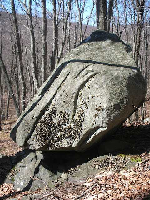
Large Boulder perched on edge of slab, from east.
Leading Uphill from east of Pinnacle, Hill labeled X99, three large stones.
Cellar Hole slightly off trail.
Well for Cellar Hole.
Tall Standing Stone, well over 6-feet high.
Thursday, March 31, 2016
Saturday, March 26, 2016
Giving the Shenipsit Section between Route 190 and Gulf Road a try today. 5.1-miles, beautiful day. There are some interesting stone piles slightly off the trail, several of them in a close proximity. It is possible to look at my map and see where I "stumbled" around a bit looking at and photographing these mounds.
Close Up of Stone Mound.
Longer Shot of Mounds.
Friday, March 25, 2016
A trip to visit my parents in Adams made it logical to stop in Ashfield on Route 116 / 112 to enjoy Ashfield Trail network. Slight rain, but not too bad. 3.9-miles of fun.
Locally famous Sherman Springs!
I've made a point of noticing markers along my travels. I respect and feel the loss. I pass by this roadside memorial often when traveling to visit my parents. It is on Route 9, in Cummington or Goshen. Here is a photo from today, followed by one I had taken years ago when it had been freshly painted.
March of 2016.
August of 2005.
Sunday, March 20, 2016
Saturday, March 19, 2016
Friday, March 18, 2016
Wednesday, March 16, 2016
Thinking about reviving our mid-week trail runs from a few decades ago... the Bald Mountain Pond / Marsh area has many new trails to explore, so we explored a 4.2-mile run. As is the case with Soapstone Mountain area near the Tower, there are many, many intersecting trails here that are unmarked and unblazed. Be aware of your direction if exploring, especially later in the day.
Wuzzam and Tedziu, post run.
Route taken, northern most section was our turnaround point due to fading daylight.
Sunday, March 13, 2016
Saturday, March 12, 2016
Friday, March 11, 2016
Tuesday, March 8, 2016
Buried a friend and neighbor today; Sandy had a long battle with cancer, and fought hard until the end. She was a wonderful neighbor and will be missed by the entire community.
After the service, I wanted to spend some time thinking so I visited Bald Mountain Area, hoping to get to the top as well as the Pinnacle if I was to be fortunate.
Parked at the Bald Mountain Preserve off Scully Road.
Ended up finding what I was looking for, in slightly over 7-Miles.
After the service, I wanted to spend some time thinking so I visited Bald Mountain Area, hoping to get to the top as well as the Pinnacle if I was to be fortunate.
Parked at the Bald Mountain Preserve off Scully Road.
Ended up finding what I was looking for, in slightly over 7-Miles.
Small Pond at beginning of Route to Bald Mountain, approach from the west.
Large Boulder near above pond, approach from the west.
Balanced Rock below the Pinnacle.
Stone Wall North of the Pinnacle.
Mound and Balanced Stone, north of Pinnacle.
Close up Balanced Stone, north of Pinnacle.
Sunday, March 6, 2016
Getting out on Shenipsit Trail, off Galbreath Road. I was hoping to run over Bald Mountain and the Pinnacle, recreating part of an old run a bunch of us used to do every July (Thanks Kevin S). It has been a very long time since then, and I hadn't visited Bald Mountain or the Pinnacle in well over a decade.
As I hit what was sort of the first peak of the day, on the Blue Blazed Shenipsit Trail, I realized that I wasn't on Bald Mountain, and I wasn't west enough. Evidently, the old Shenipsit Trail has been re-rerouted! I have to admit, the work done on this new section is phenomenal. Bald Mountain and the Pinnacle would have to wait for another day. Ended up with 8-miles on my legs.
The Whistling Tree.
Huge Grouping of Stones uphill from the trail.
Balanced Rock slightly off trail, looking easterly.
Same Balanced Rock, looking westerly toward Bald & Pinnacle Ridge.
An Old Well, I've located a few of these in this section of forest. No Cellar Hole nearby.
Route from the Day.
Subscribe to:
Comments (Atom)


