WMAC / Dion Snowshoe Series interview at Hoot Toot and Whistle...
Monday, April 24, 2017
Sunday, April 23, 2017
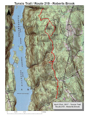
Since last Sunday at Tunxis was so rewarding, I went back to cover Route 219 north to Roberts Brook, and back. Outstanding weather, high 60's and sunny with no humidity. 11.2-miles in about two and a half hours.
Today's Route
Top of Indian Council Caves
Roaring Brook, cooling off point
Approaching Pine Mtn from the south
Roberts Brook
Small Falls upstream from Roberts Brook Crossing
Liddy, Tippi and Sam's favorite pool off Pine Mtn
Total 13-mile Tunxis section, Rt 20 to Rt 219
Saturday, April 22, 2017
While it was supposed to be clear, the rain kept up throughout the day. Granted, it was just a drizzle, but it still wavered my motivation. I stuck fairly close to home and drove to McLean, thinking I would enjoy the 5 1/2-mile loop I often do.
I made it out to the Bissell Brook crossing (which, unless you want wet feet is a balancing act on a large, smooth, bark-less tree limb stretched across the brook, about 20' or so). The limb was slippery and impossible to navigate, so I turned around and did an out-and-back. Somewhere around 4.4-miles.
Map of the full route, I turned back at Bissell Brook
Map of the full route, I turned back at Bissell Brook
Skunk Cabbage
Friday, April 21, 2017
Thursday, April 20, 2017
Wednesday, April 19, 2017
Tuesday, April 18, 2017
I've completed the map for the Tunxis Marathon route. The plan is for a one directional venture, north to south, beginning at Granville State Forest and joining up with the Tunxis Trail just north of Route 20 (joining the Tunxis at the Hurricane Brook Shelter). Map measured at 25.8, so it will be a bit longer than that in the real world.
Monday, April 17, 2017
Sunday, April 16, 2017
Easter Sunday, beautiful day with clear blue sky and temperatures approaching 80 degrees. Wuzzam wanted Tunxis, and he wanted about 12-miles. We managed 11.60.
Our thoughts through this run turned toward our dogs. The little brook with all the cascades near the Balanced Rock has always been a favorite spot for Liddie, Tippi and Sam. The one pool in particular, with a little bench on the side....
Wuzzam asked me about trail racing, and if I ever think about entering a race again. I thought about it a bit. I've raced probably 300 events or more, but none in the last 5 or 6 years (honestly, I just don't remember). I mentioned feeling as though in a race we follow the rhythm of the race, which is fun and fine. But on our own, we can just follow the rhythm of the forest. No one and nothing to distract us from the pace the woods wishes us to understand. I like the idea of following the plan that the forest has for me.
Roberts Brook
Old Foundation
Balanced Rock
Saturday, April 15, 2017
We had three birthdays to celebrate today (Tracy, Donnalee, and Otis) and Easter a day early. Pop, JC and I also drove up to High Bridge to search for the Lead Mine. Pop said he was last there 67 years ago, and we felt confident.
Pop and I found two cellar holes, and JC wandered up higher and found the mine for us. On the way back, we spotted a large chunk of Chaga on a birch tree. Total hike ended right at 2-miles, with two crossings of the Tophet Brook without any of us getting our feet wet (water is high & roaring now).
1st Cellar Hole
2nd Cellar Hole
Low and Behold, the Lead Mine
JC on top of the Lead Mine
Pop & JC at the Lead Mine
JC & I at the Lead Mine
Chaga on Birch close-up
Chaga on Birch
Also, on this day in 1996, I was fortunate to run the 100th Boston Marathon. It was my 10th marathon completed, in a time of 3:24:14.
Friday, April 14, 2017
Scheduled Easter Ham pick-up at Perkarski's in South Deerfield, so I rambled into Conway State Forest to check out forest road and trail conditions from the late February tornado. I covered just under 8-miles (7.8) and saw that White Pine didn't hold up well.
I'll check in with DCR to see if there are any plans for cleanup, etc. This is not a heavily used state forest, so I am not sure what the priority will be. Snowmobiles use it in winter, so I imagine the main forest roads will be cleared out. Hunting is popular here, but I don't know how dependent hunter's are on the trail system. There has been a really wonderful series of single track trails through the forest, unmarked and obscure for the most part. Some made it, some didn't.
Parked at the Church off Rt 116 and crossed the Burkeville Covered Bridge
A look off Joe Herrick Gulf
Nice stonework along a forest road
Cellar Hole
Cellar Hole
Plaque inside Covered Bridge
Thursday, April 13, 2017
Wednesday, April 12, 2017
Tuesday, April 11, 2017
Back to East Granby Farms after a valuable yard-work day. Connected the old path fairly easily, with the only setback a brutal thorn that stuck in my forearm and swelled achingly.
Map included, the climb towards the metacomet on the northern section is crossed by briars, and they will only get worse as summer approaches. 4.5-miles in 84' degree heat. Not a bad run.
Subscribe to:
Comments (Atom)


