Tuesday, August 1, 2017

August 1st, 2002... Fifteen Years Ago Today Part 1...

Going back to 2002, 15-years ago today, and a camping trip in Savoy Mountain State Forest. I have pictures dated for August 1st & August 2nd.

A nice thing about the August 1st pictures, the reminder that they offer, is what "Lost Pond" once looked like.  It was beautiful, and clear, with two or three levels or tiers of beaver ponds below it.  At some point in time, about ten-years ago, the beaver activity really increased and changed the entire landscape.

At some point this fall, I plan on going back and covering the Blackburnian Loop, the North Pond Loop, and the fairly recently named "Lost Pond Trail".  It will be interesting to see what the area looks like, as my last visit 3 or so years ago showed a very changed landscape.

From that day fifteen years ago at Lost Pond, I also ventured up to Spruce Hill from the Blackburnian Loop, or Lost Pond as it is now called.  What a peaceful spot to sit and think.

Tower Brook, most likely
Stream pathway through rock
One of the lower tiers of beaver pond
Lost Pond looking toward Spruce Hill
Tips swimming at Lost Pond
Lost Pond
Tippi at Lost Pond
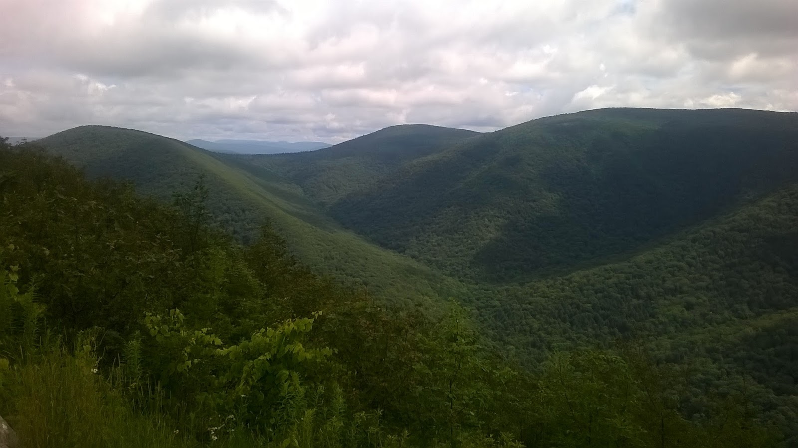
Looking west off Spruce Hill towards Greylock
Looking south off Spruce Hill toward Borden Mountain (Tower 51)

Monday, July 31, 2017

One thing I've been meaning to do is complete the Bear Swamp Trail off Pulpit Rock, down to the bottom, and someday to Monroe Bridge.  Once at Monroe Bridge, I know that Kingsley Hill Road is nearby and part of a snowmobile corridor, which may allow for future extensions of my circled world.

Monroe Bridge would have to wait, but I did get to the bottom off Pulpit Rock.  That is the good news;  the bad news is that I was really exhausted at the bottom and knew I'd have to climb back up the mountain...  and it is very steep.

This trail will really be great, once it's finished.  My fear is that Brookfield Renewable Power may consider the Bear Swamp Hiking Trail complete as it stands.  I honestly don't know the answer, but Wuzzam and I traveled a part of this on May 27th, 2016 and it appears the same as it did last year, except grown in a bit more.  The plus/minus is as follows:

  • The Blazes and metal Bear Swamp Trail circular markers are done really well.
  • The Trail off the snowmobile trail to the substation is fairly hidden, and you have to either know it's there or get really lucky.
  • That trail down to the road crossing is very, very difficult to follow on the ground.
  • Once crossing the road, on the way to Pulpit Rock, the trail needs to be traveled.  Honestly, I think I could see that a person had gone through recently, but it may have been only one over the last few months.  The markers and blazes are great and plentiful, but the trail on the ground is in danger of vanishing if it isn't trimmed back this year or next.
  • I noticed several balanced rocks along the trail, which is awesome.
  • The views at the openings, including Pulpit Rock, are magnificent.
  • There is a very large slab of rock along the trail north of Pulpit Rock which allowed me a view of Greylock, which really was a highpoint.
  • Once the trail begins the descent, it is very steep and narrow.  Not only are more switchbacks necessary, but bench-cutting is needed as well.  I normally wouldn't mind, but this is a trail that Brookfield Renewable Power had hired New England Environmental, Inc to develop and maintain.
  • At the bottom to Monroe Bridge, I didn't venture along the flats but it looked grown in with knee high fern.
  • Many signs of Moose along the ridge route.
The day brought me 8.4-miles on my legs, with a very difficult climb in the middle.  The trail tread isn't really set yet, so none of the route is easy going.  It is in an incredible area, so I'll be back to see if any maintenance or improvements are made.

Roadside Memorial along Route 2 in Greenfield
 Balanced Rock
 View down toward Dunbar Brook Picnic Area
Another Balanced Rock
 Off Pulpit Rock
 Do you see our winged friend?
 Moss leading to Pulpit Rock
 Yet Another Balanced Rock
 Signage along the bottom, my turn-a-round point
 Moose Sign
 Moose Sign
 A View of Greylock in the Distance
 

Sunday, July 30, 2017

An outstanding summer day for Connecticut, cool in the high '70's with no humidity and plenty of sunshine in a blue sky.  My legs seemed like they were recovering pretty well from the long day on Greylock, so I drove to the Metacomet on Route 20 to run out to the notch and back, for 5.8-miles.

Looking south off Peak Mtn (Copper Mtn), towards Hueblin Tower and Talcott Mountain
Looking west down to Old Newgate Prison
Remnants of an old stonewall crossing over the ridge

Saturday, July 29, 2017

I woke fairly early and quickly drove out to the Suffield, Connecticut - Southwick, Massachusetts bike path today (Farmington Canal Heritage Trail & Southwick Rail Trail) to run an easy 3-miles before heading to visit my folks.  Parked near Congamond Road, and went north for a bit, and back.  It was a good enough run at 10-minute pace to keep my legs from going into rigor mortis after yesterday's effort.  It is always good to visit the rail-trails and visualize up close how many people use and enjoy these paths.

Visit with the folks was great, as is normal.  I brought along a box of Mrs. Murphy's donuts for them, and picked fresh, ripe raspberries to take back home.  An outstanding day!

Heading back south on the Southwick Rail Trail

Friday, July 28, 2017

It has been a very long time since I've been on Greylock.  Having grown up in Adams, the mountain is part of me, yet I haven't connected with it recently.  Wuzzam and I decided to change that today.

We would park along Rockwell Road, at the CCC Dynamite Trailhead lot.  This is directly across from Sperry Road, which has been closed to vehicles for a few years now.  Route as follows:
  • Sperry to the Hopper Trail, and drop down to Hopper Road, at roughly 1,000' elevation.
  • Up Haley Farm Trail to Stony Ledge lookout at 2,560' elevation.
  • Down the Stony Ledge Trail to the Roaring Brook Trail at roughly 1,200' elevation.
  • Up Roaring Brook to the Deer Hill Trail, 2,250' elevation.
  • Down Deer Hill to the Falls, and then climb back up to the Campground Trail, which is a real rollarcoaster down and up!
  • Campground Trail out to Rockville Road, down the Road for a quarter mile, and down Greylock Road to the Stage Trail.
  • Stage Trail to Jones Nose.
  • Up Jones Nose to the CCC Dynamite, and the Dynamite back to the car.
Total of 13.2-miles, beautiful low 70-degree temperatures with no humidity and no bugs.  

We held up really well on the long Haley Farm Climb, remembering most of it from the Greylock Marathon Runs.  Roaring Brook was the toughest for both of us, it has turned steeper and longer than I had remembered.  Deer Hill was as I recalled, difficult heading down and a chore climbing back up.

By the time we hit Jones Nose, even that climb stressed us.  Neither of us have climbed like this in some time.  It was beautiful, and encouraged us to make this trip much more often.

View northwest from Haley Farm Trailhead

Climbing Haley Farm, Wuzzam is in a green shirt in the middle of photo

Looking towards Williamstown from Haley Farm Trail, two-thirds up

Looking off Stony Ledge, with Prospect on the left, Fitch and Williams on right

Wuzzam on Stony Ledge, Greylock behind him

Another view off Stony Ledge, with a nicer focus on The Hopper

The bottom of Deer Hill Falls

Stream after the falls from the bridge

Wuzzam on the bridge

Jones Nose


Also, on this day in 2005...

Tippi and I ran the Savoy General Store Marathon.  It was lengthy, over 29-miles I believe.  From Haskins Road to the General Store, which brought us all the way over to Windsor Jambs, we had the company of "Max", a friendly dog we picked up at Loop & Haskins intersection. 

Tippi along the trails of Savoy, 2005.
 Oddly, each time we came to an intersection on the trail, "Max" knew which way we were planning on turning (even though he lead).  He managed this for 9 - 10 miles.

Total for the day was roughly 29.30-miles in 6:17:52.  It was my 27th completed marathon, and Tippi's 3rd.  After finishing, I met Jane Phinney in the Savoy Town Offices;  she was the Savoy Town Clerk and is the author of  "Taking the High Road". 


Thursday, July 27, 2017

After Saturday's run to the Pine Cone, I decided the time was ripe to bushwhack from Enders State Forest up to the Cone.  It looked to be somewhere around a mile, and I had the waypoint on the gps so it would be fairly easy finding my way (as long as I could avoid heavy mountain laurel stands).

Heading up, I encountered an amazing ceremonial stone pile in the middle of nowhere, which I would commit to memory for the return trip.  It rained slightly, but the leaf coverage was pretty heavy so I managed to stay somewhat dry.  Made it to the end of Pine Cone easily enough, at around 1.2-miles.

Going down, I decided to keep a slightly straighter bearing on the stone-mound.  Worked fantastically, so I'll get out here in the early winter and place some flagging up for the connection of the circled world.

Once down to the stream, I followed the trail(s) to the south-side, crossed after the last falls, wobbled a bit further east before turning around and coming back on the north side of the stream.  Water over the falls was plentiful and loud!  Managed a total of 3.1-miles while having this fun.