Monday, March 5, 2018
Sunday, March 4, 2018
Saturday, March 3, 2018
Friday, March 2, 2018
Thursday, March 1, 2018
Wednesday, February 28, 2018
Continuing to track my "peaks", or at least "high points" along the trails I cover. February looks a bit better than January.
February's High Points:
February's High Points:
- Skyline Overlook, Somers, CT
- Goat Rock and Lookout Point, Hampden, MA
- Minnechoag Mountain, Hampden, CT
- "Nick's Hill", West Suffield Mountain / Metacomet Ridge, Suffield, CT
- Hill 880', Hampden, MA
- Pine Mountain, Hampden, MA
- Perkins Mountain, Somers, CT
- West Ridge, DAR State Forest, Goshen, MA
- Walnut Hill, Williamsburg, MA
- Copper - Peak Mountain, Metacomet Trail, Granby, CT
- West Suffield Mountain, Metacomet Trail, Suffield, CT
- Merritts Hill, Williamsburg, MA
- "Nick's Hill", West Suffield Mountain / Metacomet Ridge
- Bald Mountain, Shenipsit State Forest
- The Pinnacle, Shenipsit State Forest
- "Balanced Rock Hill", Shenipsit State Forest
- "Bent Birch Hill", Shenipsit State Forest
And, from old gps data, it looks as though Tippi and I were on a Hawley Notch snowshoe this day (February 28th, 2008) ten-years ago.


Tuesday, February 27, 2018
Here is the flyer for my friend the Woods Walker's presentation this evening. I assisted with the slides/images for the third time on this year's Rock Show Tour.
Again, like the prior two presentations, a full crowd of very interested people, both young and old. It appears people are hungry for all things nature oriented.

And, from old gps data, it looks as though Tippi and I explored the Dubuque State Forest in Hawley, from Middle Road to East Hawley Road, this day (February 27th, 2008) ten-years ago.

Monday, February 26, 2018
Back out to Skyline Scenic Area in Somers, CT to wrap up the segment from South Road back up to the Skyline Trail. Spoke with Kevin S to get my bearings, as it "looked" different last Friday when I didn't make the connection.
Found my way relatively easily, saw a few options and remembered the old "correct" route. It was much more traveled and wide-open today verse when we ran here regularly in the early 2000's.
Totaled up 4-miles in sun and forties temperature. Not a bad Monday for February!
Large Boulder on the Skyline Trail

Another view of the Boulder

Old forest road with small stonewall over stream and rock bed

View west of Skyline's Peak


Sunday, February 25, 2018
We are still stuck in a rainy pattern for weather; I waited until 4:00 p.m. when the rain was due to finally leave. Managed 3.8-miles along Main Street.
And, 15-years ago today, February 25th, 2003, Tips & I visited Dubuque State Forest in Hawley...
And, 15-years ago today, February 25th, 2003, Tips & I visited Dubuque State Forest in Hawley...
Tippi Crossing the Brook along Sprague Road


And, from old gps data, it looks as though Tippi and I explored Cummington and Plainfield snowmobile trails on this day (February 25th, 2008) ten-years ago.

Saturday, February 24, 2018
An afternoon drive to Williamsburg to see if I could find the route from the Bradley Sanctuary to the Tilton Farm Trail area at DAR State Forest. A part of this was the old snowmobile corridor, which I last visited on May 29th, 2012.
Bradley Sanctuary looks well maintained and in great shape. The connector from Bradley around Nichols Swamp went well, but the old woods road past the gravel pit and old cemetery (which I've never seen) was a true mess due to logging. I ended up bushwhacking until I found another old woods road, and exited on Brier Hill Road instead of Wing Hill Road, about 8/10 off.
I needed to be a little lower on the ridge, close to Rogers Brook. I'll venture out again to run from the north and head south. The biggest issue is the heavy logging, which has always been present, but right now is brutal. I feel confident I can connect the pieces, and I also will head east from Bradley toward Conway State Forest.
Heading back, I noticed a large stonewall toward the top of Merritts Hill, so I ended up bushwhacking again through a mess of downed trees and stumps. I finally emerged on a woods road, which looked like it was heavily used for the logging operation. Ended up with 5.7-miles, and I just beat the rain!
Bradley Sanctuary Kiosk

Inscribed rock for the Bradley Property

Bradley Sanctuary's Large Oak just beyond the stonewall

Nichols Brook

Nichols Brook and Ravine


Friday, February 23, 2018
Back to Hampden and a bit more "attempt" at piecing together the Old Simon's Run. Weather was bad, 40-degrees and pretty heavy rain during the drive to South Road. Once I arrived, the rain sort of stopped, and I was on my way.
I parked adjacent to where we would exit onto South Road at the most southern point... the trail still looked like it was being used by motorbikes at least occasionally. I followed through the mud, brier, and water further than I thought I should have, and came upon a busy intersection and a house up on the western most portion of a hill. I stuck with the northern route, placing the southern option in my memory bank for another day,
This intersection was the climb up to Pine Mountain, and it did not look familiar to me until I was at the top. Truthfully, we always navigated this course in the opposite direction of what I was doing today, and it has been about 20-years since I was on it. I guess this explains my lack of noticing.
So, the good news is the other option at the base of this climb should bring me to Rattlesnake, or in the general vicinity. That gets me across from the Camp Ayapo trails from yesterday's run.
Sticking north, I dropped off Pine, and from the top down the north-side it was totally familiar. I thought about the Wednesday night run long ago in a tremendous Thunder and Lightning storm, with huge chunks of hail tormenting us and lightning crashing right around the group. God Bless Tippi for hanging in with me during that night.
Up 880, which I remembered well, but down the north-side seemed a little different. Toward the bottom it was really different, and I have to also admit that we always ran this in the summer with leaf on the trees. The forest was open and bare today.
Exited on South Road exactly where I had hoped to, across from the power-lines heading up the Minnechoag Mountain Trails. The old Simon's Route is really coming together.
Once back at the car, I headed a bit more south on the road to see if I could spot the re-entry into the woods to join the Skyline Trail, but it began to rain hard again and I called it a day with a little over 5-miles total. A wonderful, rewarding day.
On the top of 880, looking at Pine Mountain to the south

Foundation along South Road


Thursday, February 22, 2018
Drove out to the old Camp Ayapo in Somers, Connecticut today. This is a piece of the "middle" missing from the old "Simon's Lost in Hampden" adventures.
Back on January 27th, Wuzzam and I arrived opposite the old camp at the trail-head for the Stevenson Woodlot. Then, in early February, the 1st & 2nd actually, I had explored the Skyline Area and Minnechoag Mountain area as well. The Hill 880', Pine, Rattlesnack, Perkins and Ayapo are what remained for exploring.
So today, it was to the easiest missing spot; Somers Open Space has been improving the trails around Ayapo for a few years now. It was really enjoyable to see the hard work placed into this wonderful area.
Back in the 1990's, DL and I fished Hurd's Lake several times a week, in our Old Town Canoe with our spaniel Dusty always in the boat as well. We spent several years in that water.
Then, for a couple years in the early 2000's, JC would attended summer camp at Ayapo. I would drive out most Friday afternoon's with Tippi to pick him up.
This spot really holds some wonderful memories for me, and today only helped further cement them in. Ended up with 3.8-miles after a light snowfall.
New signage with an accurate map!

Looking back across Hurd's Lake from the north


Twenty-years ago today, February 22nd, 1998, I directed the second WMAC Snowshoe Series Race at Dubuque State Forest in Hawley, Massachusetts.
1st Annual Hawley Kiln Klassic 7-Mile Snowshoe Race
February 22nd, 1998 - Hawley, Massachusetts
The event had 8 starters and finishers, including Old Farmer Tom who tried to snowshoe and mountain bike through the course. We wrapped up an awesome first ever weekend of snowshoe racing, and were on our way!
Wednesday, February 21, 2018
Twenty-years ago today, February 21st, 1998, I directed the first WMAC Snowshoe Series Race at Savoy Mountain State Forest...
1st Annual South Pond Shuffle 4-Mile Snowshoe Race
February 21st, 1998 - Florida & Savoy, Massachusetts
The event had 36 starters and finishers, and circled North Pond, South Pond, and Tyler Swamp. Our snowshoe series began during the 1995/1996 season, but this was the first actual "race".
The series is still going strong in 2018, but I "retired" from organizing and directing after ~20-years in 2016. When I look back, it was a huge portion of my life given to the series. The many awesome memories, friends, and laughs made it really special. I'll never forget the fun snowshoeing provided.
Tuesday, February 20, 2018
Monday, February 19, 2018
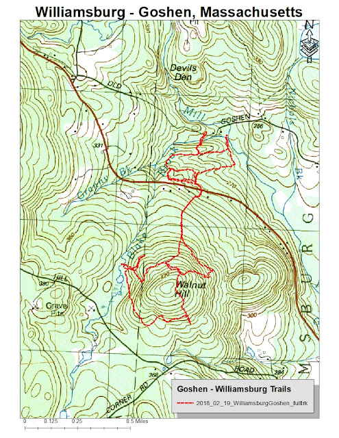
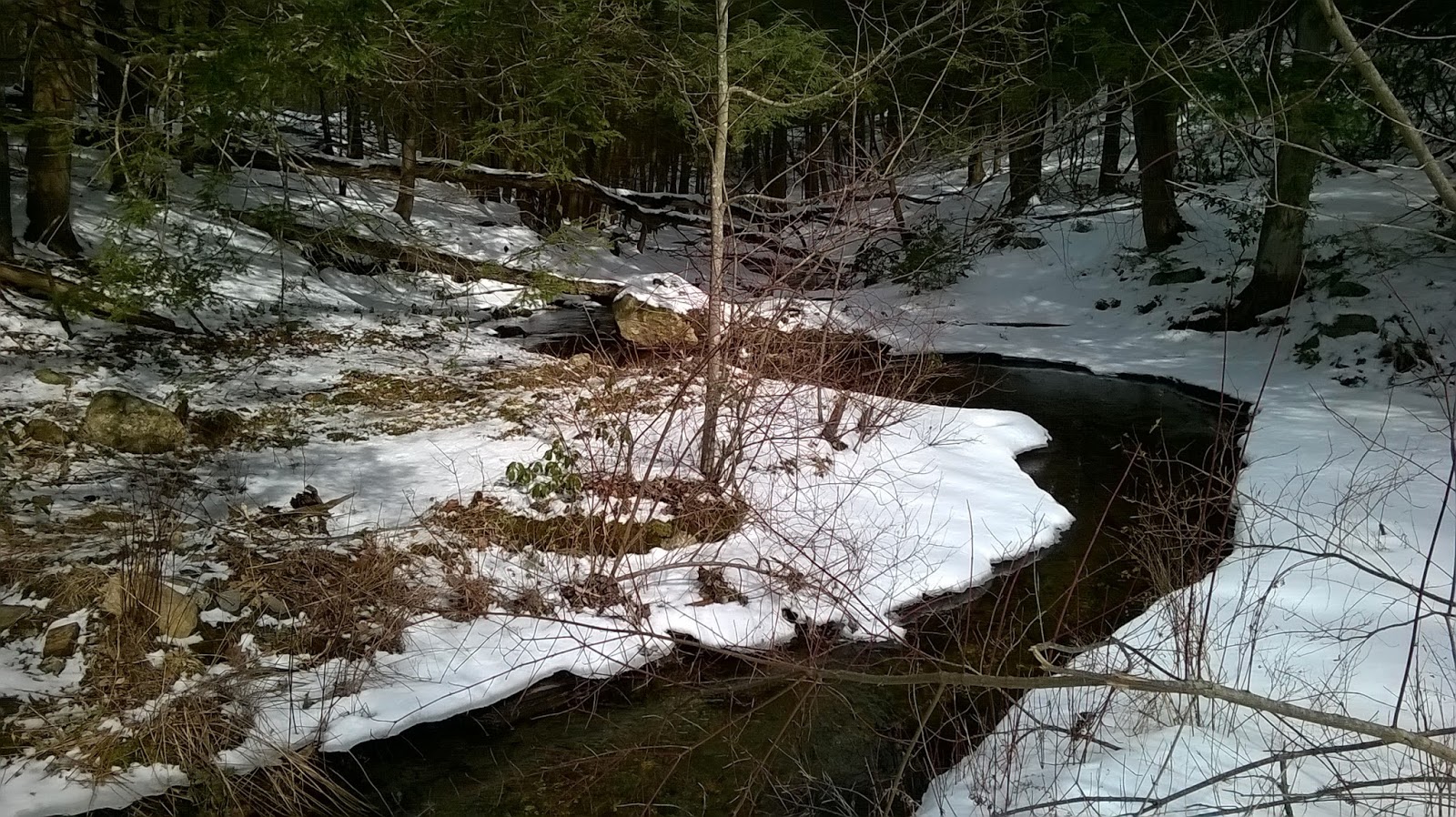
Presidents Day today, drove out to Williamsburg/Goshen to connect the snowmobile trail from Route 9 at the Breckenridge Property to above the solar panel field. Finished with 4.9-miles on snowshoes.
Above the solar panels on Walnut Hill I watched a lone coyote scamper away through the snow, which was my first glimpse of a coyote in a few years. While moving through the Breckenridge Property on the east side of Route 9, I witnessed a red-tailed hawk passing through the hemlock.
The day was a success as I completed the connections I had hoped to; an uninterrupted path from DAR State Forest to the Breckenridge Property and Old Goshen Road. The next bit will be a southward 1/2-mile journey to join the Bradley Property, which used to get me to DAR or Conway State Forest via snowmobile corridor routes. I plan to check the condition of those passes.


Perched Rock on Walnut Hill


From the Archives... On this day in 1995, the 1st Moby Dick Marathons were held. This was my 5th marathon, with the 28-miles completed in 5:01:00.
Above the solar panels on Walnut Hill I watched a lone coyote scamper away through the snow, which was my first glimpse of a coyote in a few years. While moving through the Breckenridge Property on the east side of Route 9, I witnessed a red-tailed hawk passing through the hemlock.
The day was a success as I completed the connections I had hoped to; an uninterrupted path from DAR State Forest to the Breckenridge Property and Old Goshen Road. The next bit will be a southward 1/2-mile journey to join the Bradley Property, which used to get me to DAR or Conway State Forest via snowmobile corridor routes. I plan to check the condition of those passes.
Blake Brook east of Walnut Hill
Interesting stonewall running into a large boulder on Walnut Hill

Perched Rock on Walnut Hill

Another view of the Perched Rock on Walnut Hill

Blake Brook in the Breckenridge Property

Bridge over Blake Brook in Breckenridge

Trailhead Signage on Old Goshen Road


From the Archives... On this day in 1995, the 1st Moby Dick Marathons were held. This was my 5th marathon, with the 28-miles completed in 5:01:00.
It seemed like a good idea, but there are reasons why the event didn't last, especially as a 28 or 30 miler. Bitter cold, difficult, no aid, February on Greylock.... seems like there would be many additional "whys".
This run was really special for me, it cemented my friendship with Paul. We ran the entire event together, and began to dream up our snowshoe series. Paul and I ended up roaming the woods together for a very long time, we see the same things in nature.


Subscribe to:
Posts (Atom)