Tuesday, June 5, 2018

Legs are a bit tired from the race Sunday, but it was a really nice day, and really cool temperatures, so I drove out to the West Suffield Bike Path (Farmington Canal Heritage Trail & Farmington River Trail) to jog a slow and easy 3-miles.

View from the Parking Area of the Metacomet Ridge

Old accomplishments ~~

On this day in 1994 I completed my 3rd marathon - Nipmuck.  It was my first Nipmuck Marathon completed, and my time was 4:02:00, good enough for 23rd place.

Also, on this day in 2005, I completed my 25th marathon - also Nipmuck, with a time of 4:48:13.  This was good for 29th place.

Monday, June 4, 2018

Afternoon meeting at SCA Americorps at Dubuque State Forest in Hawley, Massachusetts with Dubuque / Hawley State Forest Stakeholders.  Really good turnout, representing many multi-use groups.  

I've done some mapping in the past, trail monitoring, and of course multiple snowshoe events within the forest.  And, of course, I've just been a "visitor".

One thing suggested was starting a "Friends" group for this forest.  I hope to be involved.

Sunday, June 3, 2018

Wuzzam asked me to go to a race today, the Goodwin State Forest 30km.  I don't think I've been to a trail race since Nipmuck Marathon 2012 and Goodwin 2014, so this was a pretty big leap for me.

The weather looked really promising, basically nothing worse than mid-seventies with no humidity.  Because of this forecast, on Saturday night I told Wuzzam that I would be about a 25% chance of making the start line.  He said he wouldn't spend too much time looking for me then.

Goodwin is a special place for me, I have done my naturalists training there, and I think very highly of  the Friends who support the forest.  If I was going to run a trail race, this should be one of my first choices anyhow.  I was plenty familiar with the trails, as I had done the 1st Annual Goodwin 30k back in 2014, and I've usually run after the naturalists training.

So, I woke early enough to take the 50-minute drive and register for the event.  I was eligible for the "geezer" discount of $28 race day.  The race began after a pretty lengthy introduction by the race director, and I found myself well at the back of the pack.  One reason is that I haven't raced, and I am slow.  Another is that the race includes a 10 km version, which has about double the participants of the 30 km, and those runners took off quickly.

I remembered many of the trails and most of the landmarks along the way.  I ran steady, without any walking at all, and had no mental fatigue whatsoever.  My ankle felt fine the entire day, as did most everything else.  No complaints on this beautiful day.

I had run this event in 2014 in 3:37:36, which was good for 18th of 37th place.  Today, I managed 3:49:25, and 19th of 40-finishers.  Interestingly, I was passed with about 10-feet to go, which knocked me out of 18th again.  I have confidence that I am not far away at completing a marathon due to the fitness I showed today.

I was reminded today why I stopped racing a few years ago...

1) Having to arrive an hour early (or more) to do a run.
2) Paying an entry fee to do something I can do on my own.
3) Having to be at a certain place, at a certain time, and then depend on the event to be on schedule.
4) Crowds for the first several miles, havoc for the footing and rhythm.
5) At some point, despite best intentions, it becomes a race.
8) Like it or not, effort and speed tend to pick up at a race, which makes recovery longer.

On the plus side of things, the advantages I can think of are...

1) Water Stops and Aid Stations equipped for us at sensible locations.
2) A better work out than "just being out there" alone.
3) Awesome volunteers.
4) Supports a "good cause".
5) Trail Runners tend to be friendly, positive people.

One thing I noticed back at the last Nipmuck Marathon I did, and it was true again today, is that I didn't really know more than 4 or 5 people at the entire event.  During the 1990's and 2000's, I actually knew and spoke with 50 or 60 regulars at any of the dozen or more trail races I entered.  It seems like many, like me, have decided racing wasn't for them any longer.


Saturday, June 2, 2018

Took a drive out to Williamsburg / Conway for an attempt at locating a plaque set in a large stone commemorating The High Street Walking Club and Edward C. Gere, circa 1926.

I've made minimal attempts at locating this monument in the past, but haven't succeeded.  Today, I was armed with some added data from a geocaching site, and felt pretty confident regarding the  available directions.

The parking area is along Nash Hill Road in Williamsburg.  In the psat it had been possible to come up from the east on Williamsburg Road, but the bridge has been out the past few years so no go.

This is active watershed land managed by the City of Northampton, and the old country road named "the Henhawk Trail" connects to Conway State Forest.  The main trail/route, as well as several side-paths, are utilized by local snowmobile clubs during winter.  There are numerous, lengthy stonewalls crisscrossing the forest - often climbing steeply uphill.  There are also some hard to locate single-track trails such as the route leading to the Williamsburg Wonder (balanced rock, see my post from May 19th, 2017).

Roughly 1.2-miles north on the Henhawk, where the trail finally changes to "downhill", I began a bushwhack along a stonewall heading west.  It was a easy to follow the stonewall, but it is pretty steep hiking.  Finally, I arrived up at the top, and was surprised to find the memorial plaque set in a large stone at the convergence of three stonewalls.  This feels like a really strong spot.

From the plaque, a single-track trail headed north, but after a quarter to a half-mile it seemed gone.  There was a decent amount of blow-down, and obviously this hasn't been a regularly used trail in many years.  After the first light snowfall would be a helpful time to re-explore to see if the trail could be more easily followed.

I bushwhacked north, passed by a really nice vernal pool (or actual small pond), and finally re-entered on one of the forest roads I was familiar with.  Managed to ramble my way back with 4.7-miles on my legs.

Finding the plaque was a goal for 2018, and the array of stonewalls meeting up with the location is something I need to take a look at with some LiDar data.  The undulating wall heading south is of interest to me.

Excellent day, even with the bugs being brutal and the humidity a burden.  I hope to be back in early winter to this location - to revisit the balanced rock and hopefully bushwhack from that trail to the marker following the undulating wall.

High Street Hiking Club dedicated to Edward C. Gere, 1926

This stone is the meeting place for three stonewalls

The stonewall heading south, downhill, is an undulating network

The Henhawk Trail includes an abundance of stonewall & interesting stacks

An interesting "kneeling tree"


From the archives department...  I completed my 11th marathon on this day in 1996 at Nipmuck.  I ran a 3:56:50 in the race, which was good for 15th place.

Friday, June 1, 2018

A little warm and just after the rain had fallen, the 3.7-miles along the Metacomet Trail south from Phelps Road was a welcome today.  It felt really good to enjoy the woods and loose my mind for a little bit of time.

The forest has really "greened up" since last week

Old News Department...

On this day in 1997 I completed my 14th marathon - Nipmuck.  It was the 3rd time I completed Nipmuck, and my time was 4:31:44, good enough for 42nd place.

Also, on this day in 2013, I completed my 49th marathon - Hawley Berkshire East.  I had Wuzzam with me for this one, which was a real beast.  We had a total time on feet of 7:45:15, which was the longest either of have ever been on our feet moving through the forest.  It was most likely more than a marathon distance.  By several miles...  (or more).


In the way-back department, from June 1st, 2002 (sixteen big years if you want me to do the math), a group of Adams-Boys and a few others tackled a long run on Greylock.  By the look of the pictures, I can recreate out steps... it was a longish day judging by the snapshots.

The Group at Jones Nose

Climbing Jones Nose

Rest Break after the climb

Billy leading us through CCC Dymanite Trail

Another Rest Break

Deer Hill Falls

A very young Trail Troll with Tippi

Thursday, May 31, 2018

Music 2018...

Effort #23, The Modern Lovers "Roadrunner" covered by the Primatives in 1984, the trio version (Farmer, Aldo, Lee) at "the Art Studio".

"...Don't Feel so Low with the Radio On."


Wednesday, May 30, 2018

On this day in 2009, Wuzzam and I completed a McClean Reservation Marathon in roughly five hours.   This was my 39th marathon completed.  I recall it being a fairly easy day for us.

Tuesday, May 29, 2018

After a nice breakfast with DL & Bonita (our dog friend), and some laundry, I hit the road to run the northern section of Tunxis Trail.

It was pretty warm, and humid, and the four days of no-running didn't really place me in a great spot.  I enjoyed the run north, out to the Massachusetts / Connecticut state line monument, but prior to the steep climb up towards Pell Road I thought about running the road back, just for a change.

The swampy section on-top has been improved with planking / bridgework, and the trail is in really great shape.  Actually, I've been on this section several dozen times over the years, and today was the most "easy-to-follow" I can recall.

Once at Pell Road, I headed south and passed the road heading east that drops down to Route 179 in North Granby.  A bit further along I saw an old path leading west, and decided to explore.  Luckily I did, as it was a really great connector to the Hurricane Brook Shelter along the Tunxis Trail.

Once back within throwing distance of the trail, I continued along Hurricane Brook Road back up to Route 20.  Lots of climb, just like the trail, with nice views of the stream on my right most of the way.

Managed 6.1-miles in the warmth of late May, and it was encouraging to piece together the "new" trail into my network.

Top of Trillium Hill

Hurricane Brook crossing

Hemlock and Rock 


Monday, May 28, 2018

Spent a reflective Memorial Day back in Wheaton, Illinois with JC & DL before flying back to Connecticut in the evening.  My current thought on flying, which I had done a lot of in the 1980's but have only made three recent trips (last two years), is that I enjoy driving much more.

It was a great small vacation, and I'll be back to Illinois and Cahokia.

Also, on this day in 1995 I completed my 6th marathon, Vermont City.  I had trained for a year specifically to run sub 3:10 at a marathon, so that I would qualify and gain entry into the 100th running of the Boston Marathon.

I recall feeling awful for the first couple miles, and beat from around  10 - 13 miles.  At some point, my training kicked in, despite the heat, and I finished in 3:08.  Qualified for Boston!

Sunday, May 27, 2018

Back to Cahokia to climb Monks Mound and explore the Woodhenge.  

The climb to the top of Monks Mound is split into two levels, with a flat "platform" between.  The location seems to be very popular with people training up and down, repetitively.  The views across the Grand Plaza toward the Twin Mounds is very impressive, early morning would most likely be fantastic.

The feeling I had while on top was special, as all four cardinal directions were open to me.  The Gateway Arch in St. Louis was easily in view.  Fascinating location and the work that went into constructing this landmark made an impression on us.

After about an hour on Monks Mound, we moved over to the Woodhenge, which is aligned with solstice and equinox calendar dates.  Again, amazing site.

Ended the day with some time inside the interpretive center, and gift shop purchases.  I enjoyed the visit so much, and being present at the location will help as I read through the books I have on Cahokia.  I definitely plan on another visit within the year.

Monks Mound

JC & DL starting the climb up Monks Mound

Across the Grand Plaza at Twin Mounds, from Monks Mound

From Monks Mound toward the Stockade

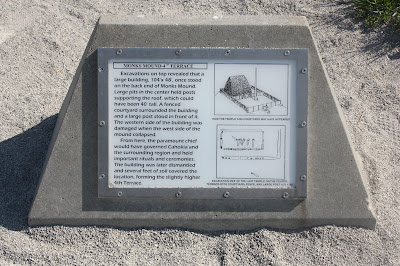
Monks Mound signage

JC Atop Monks Mound, with St. Louis in the background (including arch)

Top stairway going down off Monks Mound

Steps up Monks Mound

Monks Mound

Monks Mound signage

Monks Mound

Monks Mound

Woodhenge

Woodhenge signage

JC walking around the Woodhenge

More Woodhenge

Cahokia signage

Art on Interpretive Center doorway

Birdman Tablet at Cahokia

Saturday, May 26, 2018

Drove from Wheaton, IL to Cahokia Mounds State Historic Site & World Heritage Site in Collinsville, Illinois today with DL and JC.   It is a site I wished to see for the last couple years, and once there I was impressed with every detail.

We took a couple hours in the Interpretive Center, including the film presentation "Cahokia:  City of the Sun".   The time inside was informative, and amazing.

Once outside, we focused on a walk that would include The Twin Mounds (no.'s 59 & 60), Mound #56, and also the location of Mound #55.  We also passed through a view that extended over the Grand Plaza toward Monks Mound.

Some information on the Grand Plaza is as follows (from wikipedia):

To the south of Monks Mound is the Grand Plaza, a large area that covered roughly 50 acres and measured over 1,600 ft in length by over 900 ft in width. 

Researchers originally thought the flat, open terrain in this area reflected Cahokia's location on the Mississippi's alluvial flood plain, but instead soil studies have shown that the landscape was originally undulating ridge and swale topography. 

In one of the earliest large-scale construction projects, the site had been expertly and deliberately leveled and filled by the city's inhabitants. It is part of the sophisticated engineering displayed throughout the site. 

It was used for large ceremonies and gatherings, as well as for ritual games, such as chunkey. The game was played by rolling a disc-shaped chunky stone across the field. The men would throw spears where they thought the chunky stone would land. The game required a great deal of judgment and aim.

After our visit at Cahokia, we drove just a few miles into St. Louis, past the Gateway Arch, to Pappy's Smokehouse, which was also a lot of fun (and the food was delicious).

Mound 55 with Monks Mound in the background

Monks Mound from the edge of the Grand Plaza

Marker for the Twin Mounds

Twin Mound #60

Twin Mound #59, with Twin Mound #60 in background

Twin Mound # 60

Across the Grand Plaza toward 100' tall Monks Mound

Monks Mound again

DL & JC at the Twin Mounds


Friday, May 25, 2018

Flying into Chicago today to visit JC.  We have a trip to Cahokia planned for Saturday & Sunday.

Meanwhile, the Woods Walker's flyer for Farmington is below, "Rock Show" 2018 continues with presentation #4!