Another awesome night (low temps and low humidity). Took a 3-mile jog along Main Street in the dark, and I actually had some "kick" in my step.
Monday, June 25, 2018
Sunday, June 24, 2018


Saturday, June 23, 2018
I have been very fortunate to have a dedicated human running partner for over twenty-years. Wuzzam is a great sport, and will tackle anything, anytime. We both seem to get more out of "running" than "just running". The forest, the routes, the landscape, it all has to mean something... and to us it often does.
Today, despite calls for rain and a good chance of exploring, Wuzzam joined me for a one-way re-enactment of the old "Lost in Hampden" runs by K. Simons, circa 1999 and 2000.
We would challenge nine climbs, as follows:
- Hampden Overlook
- Goat Rock
- Minnechoag Mountain
- Hill 880' (Bald Mtn, Hampden)
- Pine Mountain
- Rattlesnake Hill
- Perkins Mountain
- The Pinnacle
- Bald Mountain (Somers)
After hitting some tough climbs in the prior two-weeks at Mohawk Trail and Hawley / Dubuque, today seemed to be comfortable. We really enjoyed the trails in Hampden Memorial Park, saw the stone chair in Garrish Park, passed through the VFW and over the Scantic River, climbed the north end of Minnechoag, managed our way over and down 880' and Pine, found our way over and down the fern covered Rattlesnake HIll, visited Camp Ayapo including Hurd's Lake and Perkins, visited the Stevenson Woodlands, managed steps up to the Pinnacle through to Bald on the "Old" Shenipsit Trail, and finally down the road to Bald Mountain Pond.
A fantastic day for my friend and I. 12.3-miles.
View east from Hampden Overlook

Wuzzam at Goat Rock, Minnechoag behind

Signage for Goat Rock

Peak of Pine Mountain, looking east

Ferns on the northwest side of Rattlesnake Hill

Wuzzam on Perkins peak

Tall Stonewall north of "the Pinnacle"

Old Shenipsit Trail Marker (the new trail is further east)


On
this day in 2012, Wuzzam and I completed a Metacomet Marathon, with a time of 7:00:00. Tippi ran the first section with us, from Route 20 to Phelps Road, and back (about 10.5-miles). Weather report was that heating up was very possible - so the DL grabbed Tippi early. This was my 46th marathon completed.

Our Route for the Marathon Distance.

Friday, June 22, 2018

Thursday, June 21, 2018
Metacomet Trail, from Phelps Road south for a total of 3.7-miles.

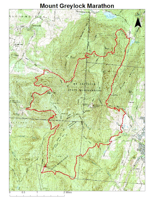

Twenty-years ago today.... On this day in 1998, my Pop and I completed the 1st Greylock Centennial Marathon in Adams, Massachusetts. Our time was 6:55:38. This was a very difficult course, with 5 lengthy climbs. This was my 19th marathon completed, and my dad's first.
Wednesday, June 20, 2018
Tuesday, June 19, 2018
"...In 2018, the New England National Scenic Trail will celebrate the 50th Anniversary of the National Trails System Act with a Hike 50 challenge. This year we join with the other 29 National Scenic and Historic Trails in celebrating this milestone."
I was sent this notification via email, and the Hike 50 Challenge seemed like it would be a rewarding opportunity, so I signed up.
"...The rules of the challenge are simple! Anyone who hikes 50 miles on the NET during the 2018 calendar year will receive a special edition 50th anniversary New England Trail patch."
I completed my 50-miles on the Metacomet, which wasn't very difficult as I visit it a few times a week year round anyhow. I completed my miles from January 1st through early April, with most of the visits to West Suffield. This was a really neat way to motivate me toward a trail I sometimes think I am too familiar with.


Monday, June 18, 2018
Sunday, June 17, 2018

Saturday, June 16, 2018
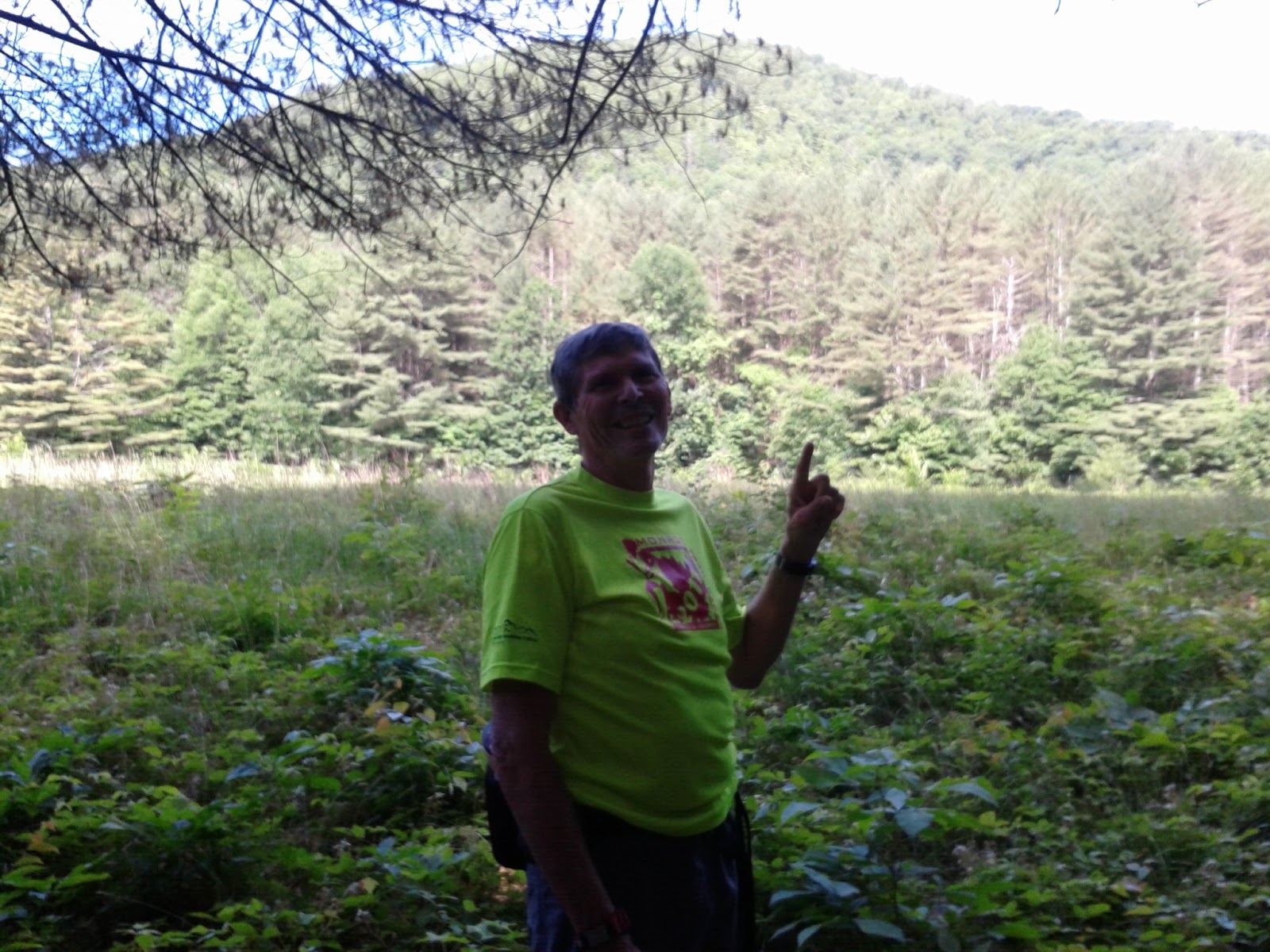
Wuzzam was game for a good day in Mohawk Trail State Forest, and he encouraged me with a quote of wisdom right off the bat...
"...kids are learning to appreciate math instead of learning how to do math".
That made me laugh, and feel a little bad about things too.
As for the good day, I had a plan for about a half-marathon distance with plenty of climbing. I also planned on showing Wuzzam some special places he hasn't experienced before.
We parked at Zoar Gap, and made our way through the Elder's Grove and it's abundance of tall white pine (I believe at least 25 of tree-men-dous heights). These include the following in excess of 150' tall:
Saheda (171.4')
Tecumseh (166.8')
Osceola (160.5')
Sacajawea (159.2')
Sitting Bull (152.9')
Crazy Horse (150.2')
Wuzzam chased a porcupine up a tree, and having felt the power of the earth through the Elder's Grove, we passed through the 1930's stand of Red Pine, and along lower Stafford Meadow and the Deerfield River on the Mahican-Mohawk Trail. We caught sight of the Cold River prior to it's confluence with the Deerfield, and climbed Little Thumper Mountain, then took the new cut off to the official Thumper Mountain and the "Gateway".
Rambled through the Campground Road to the Indian Trail up to the saddle between Clark and Todd Mountains. Wuzzam asked if the climb was as tough as Blackhead in the Catskills, which was a strange questions as he has finished Escarpment about ten or so times, with the most recent being within the last couple years. I on the other hand finished Escarpment four times, and not since '97 or so. I had to tell my friend that I had no memory of that climb up Blackhead.
On the old Clark Todd Ridge, and back on the Mahican- Mohawk, we dropped off just prior to Clark's summit and stuck to the old path to South County Road. I had a reason for this... I was thinking about getting off trail and taking the location of the old road to Manning Brook Burial Ground, known officially as Gillett Cemetery, on the old Wheeler Road I believe. Found it easier than I thought it would be, and we spent time reading the epitaphs and exploring cellar holes. Very difficult to understand that there was a community living deep in these woods during the mid-1850's.
After the graves, we were back on the Mahican-Mohawk to reach Clark's summit, and then re-trace our steps on the old ridge-top trail to the four-way intersection. Found the energy to continue east to Todd Mountain's summit, and then back and down the long steep drop to the shores of the Deerfield River. One more time through the Elder's Grove, and we were complete with 12.5-miles and a serious amount of total climb!

Wuzzam in lower Stafford Meadow pointing to Todd Mountain
Mahican-Mohawk Trail

The "Gateway" on Thumper Mountain

Wuzzam going through the "Gateway"

Summit of Thumper Mountain

Wuzzam pointing from Thumper

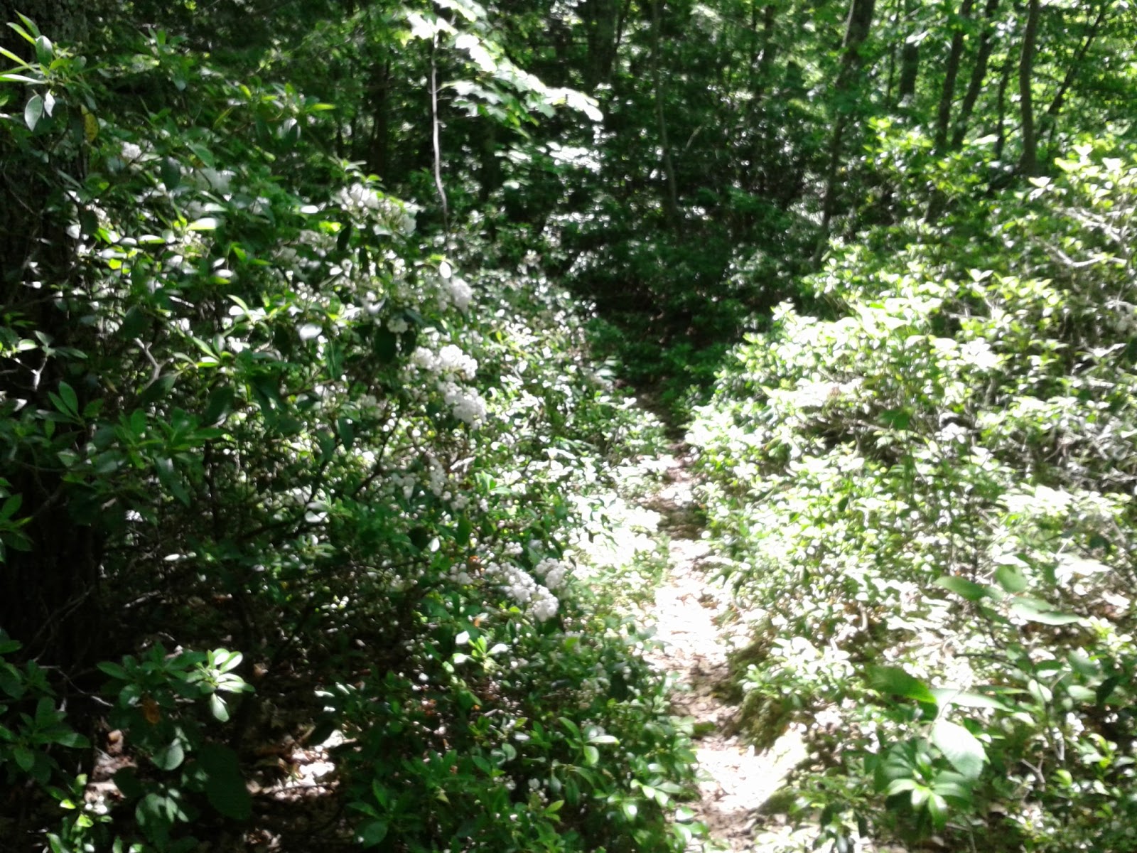
Mountain Laurel is blooming at Mohawk
Clark-Todd Ridge with views south

Gillett Cemetery along Manning Brook

Gillett Cemetery along Manning Brook

Gillett Cemetery along Manning Brook

Marker for "Freelove Rose" Gillett

White Pine along the Mahican-Mohawk Trail toward Clark Mountain

View south from the Indian Lookout on Todd Mountain

View south from the Indian Lookout on Todd Mountain

Saheda in the back, Chief Joseph & Sacajawea foreground

Friday, June 15, 2018
Penwood today to see if I could catch the Mountain Laurel in bloom, as last year I totally missed it. Took an alternative path I had remembered from years ago to the east, and for the last 5-miles stuck to the Blue Blazed Metacomet (or New England Trail) Trail. Acutally, that is somewhat true, as for the last couple tenths I moved off the Metacomet to explore a bike path.
I caught the bloom, but it looks like it might still be one-to-two weeks out. I plan on revisiting if the schedule allows. Tired legs but rambled through for 6.3-miles.

Mountain Laurel in bloom along the Metacomet Trail

Mountain Laurel in bloom along the Metacomet Trail

Mountain Laurel in bloom along the Metacomet Trail


Thursday, June 14, 2018
Back to Cowles to run the "inside loops" somewhat hard. After yesterday's jog, I thought one loop inside would be right at 3-miles. I am not sure if I am wrong or not, but I ran fairly hard, and I ended with 2.6-miles on the gps.
But, I might not be wrong at all, either. The "inside loops" turn back on themselves regularly, for the duration of the paths. It is so extreme, that at times the gps actually tracks over itself. I know from experience that under these conditions, a older gps is going to be 10% to 30% off. The unit I use is newer, with much better accuracy, but the twist and turns are going to be an issue on a trail network like this.
The deciding factor for me is that running slightly hard had me finishing in 40:30, which is much too slow for my effort today. I am not sure what the distance really is, and wont unless I wheel it or have someone with a mountain bike measure the route for me, but I am going to call this a 3-miler for reference sake. Next time I ramble through this maze, I will attempt to break 40-minutes!
Wednesday, June 13, 2018


Subscribe to:
Posts (Atom)