Tuesday, September 12, 2017

Savoy, Part III...

Savoy Town Historian Jane Benedict Phinney, the author of  "Taking the High Road:  A Two Hundred Year History of a Hilltown, was kind enough to loan me some Burial Ground information.  Below are the notes from the Estes and Dunham Lots.


Monday, September 11, 2017

Savoy, Part II...

I've visited the Estes and Dunham Burial Grounds often over the past  30-years.  I feel like sharing more photos from my visit yesterday, as well as some additional photos from 2002 and 2004 from these locations.

The transcription on the stone for "Amy" reads (to my best abilities)...

Sleep in Jesus Blessed Sleep
From which none ever wake to weep;
Yet memory clings in ones whoes worth,
So matchless was while here on earth. 

Estes Burial Ground, 2017
Stone at Estes Graveyard, 2017
Estes Burial Ground Photos from November 2004
Dunham Burial Ground, 2017
Dunham Burial Ground Photos from August 2002


Sunday, September 10, 2017

Savoy Part I

It was another beautiful day, and I drove to Adams early to visit with my parents.  Along the way, I stopped in Savoy to enjoy a run.  

The trails were as I remember them, that is fondly, but rugged (not all that well maintained).  Standing water is often an issue in Savoy, due to the layer of rock being pretty close to the surface of dirt.  Brush and small undergrowth has been infringing upon the trails for a while.  To be fair, the forest roads have been upgraded and maintained rather well (Adams Road & Tannery Road).  Both trails to Tannery Falls are in great shape, and the stone curbing, wooden steps, and fencing is actually a really nice touch now that I am used to it.

With all this in mind, I have always thought of Savoy as my favorite forest.  There is a lot of history in these hills, and many incredible landmarks.  I planned out a route, and it totaled up at 6.9-miles.  Within this loop, I enjoyed the following:
  • I caught view of both sets of windmills to the north, in Monroe and in Florida (not a positive for me as I am not a fan of these structures at all).
  • I passed by the road to Borden Mountain, or Tower 51 to the locales.  
  • The Balanced Rock was in much better shape than normal, as much of the graffiti has been scrubbed off and is pretty difficult to see remnants of.
  • Tannery Pond was picturesque.
  • The Falls were simply outstanding today.  I know everyone refers to the falls as Tannery Falls, but I never really figured out where Ross Brook, Parker Brook, and Tannery Brook fit into the picture.  There are two worthwhile cascades to witness, I'll leave it at that.
  • I stopped in to visit two graveyards along the way, the Estes and the Dunham Burial Grounds.  I'll add some data to these sites tomorrow in a Savoy Part II post.

Balanced Rock

Balanced Rock

Balanced Rock

Tannery Pond

Eastern Cascade

Eastern Cascade

Eastern Cascade

Eastern Cascade

Eastern Cascade

Tannery Falls

Stone Steps leading out of Tannery Falls

Tannery Falls

Estes Burial Ground

Estes Burial Ground

Dunham Burial Ground

Dunham Burial Ground


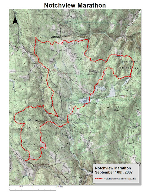
On this day in 2007, Tippi and I finished the Notchview Marathon.  We ran from Notchview Reservation in Windsor, Massachusetts into Dubuque State Forest in Hawley, then to Savoy Mountain State Forest in Savoy.  I remember that we got crushed by a heavy rainstorm for the last 3-miles.

This was my 35th completed marathon, and Tippi's 11th.  All in all, I recall not being in fantastic shape but the year was winding down, and the run was incredibly enjoyable.  I also recall missing a turn shortly after Windsor Jambs, continuing on the dirt road for a bit.

Looking at the map, we passed Windsor Pond, Crooked Neck Pond, and Hallockville Pond along the journey.  
Meadow at Notchview 
 Tippi on the Jambs Trail.
 Windsor Jambs.
 Alert, as always.
 Jambs, with Tippi on the ledge, upper right,
 Route.
 

Saturday, September 9, 2017

In 2009 I completed a Robert Frost Marathon, and my turn-a-round point was on Bull Hill Road at the small parking area and trailhead.  I ended up returning during August and September of 2009 and exploring over Bull Hill to Mt Toby, and all the way to Wendell State Forest.  My intentions were always to use that northern section for another marathon, but I've not been back.

Today, I parked at that little parking spot and ventured north with the idea of running until I spotted a memorable turn-a-round spot, and returning.  I ended up doing a loop at my northern end, by taking a chance on believing the blue trail would show up and get me back to where I had originally spotted it.

The day totaled 8.2-miles, and while I felt good my legs ached from the start.  The trail is nice, and some of it is really nice.  The ground is mainly soft and often needle covered, without a lot of rocks.  There are an abundance of forest roads, which while comfortable and easy to run, aren't always that interesting.  The solitude of this section of forest allowed me to enjoy the forest roads more than normal.  There has been some active logging throughout this area as well, which I'm not a big fan of while enjoying the woods.  

My feelings are that this is a nice forest to pass through, especially if in the middle of a long run, but the section I ran today just doesn't have anything very memorable (I'll give it another try soon in case I was just not noticing).  The trails themselves are well maintained and enjoyable, and there is a decent amount of up and down.  I just wasn't able to have a "wow" moment today.  Bull Hill is a good climb, but the summit is wooded and there isn't a sign.  I only spotted a stone-wall after I left the Robert Frost at my northern most point.  There was one small brook, which was really nice, but it was small and wasn't flowing.

I don't feel like I should be deterred to visit this section of trail again, as I said earlier it may appear more impressive within the "bigger picture" of a longer run.  I was just surprised nothing really caught my eye other than two nice rocks about 6/10's of a mile from the start at the top of the first hill.
First rock just over 1/2-mile from trailhead
Second rock just over 1/2-mile from trailhead
The Climb up Bull Hill from the south
 Small Brook Crossing
 The Climb up Bull Hill from the north
A view of Bull Hill from the road

Friday, September 8, 2017

3.5-mile run along the Metacomet Trail in West Suffield.  Enjoyable night, in the high sixties with no humidity.  It's been a while since I ran along this section, there is some logging going on about 1.2-miles north of the trailhead on Mountain & Phelps Roads.  The pictures below show the same location... the ground, and the open canopy with a beautiful blue sky from tonight.

Ground
Sky