Third run in 2018 along the 7-mile Hill Street Loop; Temperatures around 20-degrees and sunny.
Friday, February 2, 2018
Unsatisfied with ending the connection from Skyline to Minnechoag yesterday in the middle of Nowheresville, I returned today to tie it up (I was hopeful anyhow). There was a new 4" of snow along the trails in the higher elevations, which would cause some slow going.
I decided to start at the small parking area for Goat Rock at the end of Country Club Drive near Gerrish Park. Over Goat Rock and the Hampden Overlook to Hampden Memorial Park. Took the road down to the VFW, where there is a bridge crossing the Scantic River which leads to the trail network around Minnechoag Mountain.
Climbed the Algonquin Trail to the top of Minnechoag, continued south down the ridge to connect with yesterday's endpoint in Nowherevilles. Headed back and took Bob's Trail back toward the VFW, jumping two beautiful deer on the way.
Ended with 6.5-miles of slow-going running due to the ice, 4" of snow, and climbs. I think the temperature stayed around 20-degrees more or less. An Outstanding day!


View from Goat Rock

Balanced Rock coming down from the Hampden Overlook

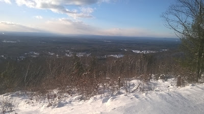
View west from Minnechoag Mountain

Bent Tree at top of Minnechoag

View east along Gas Pipeline south of Minnechoag Peak

Landmark Tree, growing along ground (I recall this "wonder" from 20-years ago)

Landmark Tree

Perched Boulders just east of Landmark Tree

Landmark Tree with setting sun

Landmark Tree

Bent Tree Limb with Old Coach Trail sign

Stone Chair opposite Garrish Park


Thursday, February 1, 2018
Wuzzam and I have been exploring the Pinnacle and Bald Mountain, and last week we found our way to the Stevenson Woodlot across from old Camp Ayapo. The Simon's Run from way-back have been on my mind, so today I went out to the Skyline Area of Somers to run the trails and see if I could find the way toward Minnechoag Mountain in Hampden. All these areas were portions of that wonderful run from '99 and '00.
About half-way into the run I scared about twenty turkey, scattering them from their comfort. Ended the day just as it was getting dark, with 3.4-miles. Best of all, despite wandering a little bit "off-trail", I managed to reconnect to the old path!


About half-way into the run I scared about twenty turkey, scattering them from their comfort. Ended the day just as it was getting dark, with 3.4-miles. Best of all, despite wandering a little bit "off-trail", I managed to reconnect to the old path!
Area sign at the small parking spot along Stafford Road

Large Boulder along the Skyline Trail


Also, from the archives.... On this day in 1998, the 4th Annual Moby Dick Marathons were held over Greylock. I completed my 17th marathon in 6:19:40, with Johnny Bandit. It was the second time I wore snowshoes for the 28-mile adventure. It would be the last time I would snowshoe this distance!
Wednesday, January 31, 2018
Tuesday, January 30, 2018
I decided to track my "peaks", or at least "high points" along the trails I cover. During January I can't say I overwhelmed climbing hills or mountains. One reason was the icy conditions for a bit of the month, another being the lack of available sunshine during the work week. Regardless, I did hit a few, as listed below:
- "Nick's Hill", West Suffield Mountain / Metacomet Ridge
- Bald Mountain, Shenipsit State Forest
- The Pinnacle, Shenipsit State Forest
- "Balanced Rock Hill", Shenipsit State Forest
- "Bent Birch Hill", Shenipsit State Forest
Monday, January 29, 2018
Sunday, January 28, 2018


Saturday, January 27, 2018
Wuzzam and K2 joined me on a ramble at Shenipsit State Forest. Temperature was going to be in the mid-forties, which is really awesome for the end of January.
Our plan was to run for 3-hours, and get a better understanding of the section north of the Pinnacle near Gillette Brook. The hope was to find more of a "path" and less of the bushwhack/grown-in-trail from last week.
Way back when, in 1999 & 2000 I believe, we did Simon's "Lost in Hampden" run from Hampden, Massachusetts to Bald Mountain in Somers, Connecticut and back. A portion of the route took us from Camp Ayapo/Hurd's Lake/Perkins Mountain over Gillette Brook on our way to the Pinnacle and the turn-a-round point at Bald Mountain. Once crossed the road at Camp Ayapo, we had to scramble through briars and blow-downs before finally picking up a trail half-way up the hill to Pinnacle. Today, we found a really nice option that exists in these woods just east of Camp Road at the Stevenson Woodlands.
As for Simon's, he also put on a regular Wednesday night 7-miler along the Skyline Trail (Northern Connecticut Land Trust), with an extension to Minnechoag Mountain, Hill 880', Pine and Rattlesnack. Several of us routinely ran this weekly, and it was pretty awesome. Development may have interrupted the section over 880', Pine, and Rattlesnake... I should explore again someday.
Back to today, we ended with 10.8-miles of sunshine running, and we found our way round. Wonderful day!
Climbing Balanced Rock Hill, with it's namesake

A view west from the Balanced Rock

Another view west from Balanced Rock, with Bald Mtn in the background

Wuzzam at the top of Bent Birch Hill

Trilogy of "carved stones" leading up from the "Bottoms"

Wuzzam at the "Twin Birch" four-way

Stevenson Woodlands, at Mountain Road

At the Pinnacle; the Shenipsit Trail once existed over this ridge!

Wuzzam at the old Shenipsit Trail marker on Pinnacle

Wuzzam at the top of Bald Mountain

Another "Notch" in the woods!


Friday, January 26, 2018

Thursday, January 25, 2018
Thought I'd add a little to the DAR GeoDatabase. Since a part of the forest is outside of Goshen, and resides in Ashfield and Williamsburg, this next image includes neighboring towns and associated road, stream, lake and elevation layers.
Conway and Cummington are also included, as I believe once I start adding trails to the geodatabase, there will be continuation into those towns as well.

Wednesday, January 24, 2018
Tuesday, January 23, 2018
Getting back to my DAR GeoDatabase, I've added the following layers...

- Elevation
- Rivers/Streams
- Lakes/Ponds
- Roads
The area of DAR State Forest is shown with darker contour elevation lines compared to the rest of the Town of Goshen. As can be seen, some of DAR State Forest resides in Ashfield, Massachusetts.

Monday, January 22, 2018
Sunday, January 21, 2018
Out to Galbreath Road to run over Bald and Pinnacle with Wuzzam. We followed a side trail we hadn't done before to the west of Pinnacle, following the path and bushwhack down to Gillettes Brook.
At this point, we bushwhacked a bit more trying to remember the Simon's Run we used to do in the late '90's. We connected with a good path that brought us up the four-way just north of Pinnacle, which we named "Twin Birch" intersection due to a nice white birch on the east branch.
Stuck to a few paths we were familiar with, and some we weren't. Ended the day with a nice 7.6-miles of enjoyable running.
Dam upstream of private bridge on Gillette Brook

Tall Stonewall north of the Pinnacle

Twin Birch

Wuzzam pointing to a balanced / perched boulder east of the Pinnacle

Soapstone's Notch

Wuzzam at the Monolith / Standing Stone


Subscribe to:
Posts (Atom)