Friday, July 13, 2018

Tunxis area to check on a side-path off Pell Road, I've been wondering where it went.  It didn't go far, just a turn-a-round / party spot after 1/8-mile or so.

Followed Pell Road into Massachusetts, to the field north of the Tunxis Trail, for a total of 6-miles.


Thursday, July 12, 2018

Made it out to Main Street in the evening for 3.0-miles.

And, from 15-years ago today, July 12th, 2003, camping in Savoy Mountain State Forest...  I sure do miss camping and all the fun that goes with it...

View from Cabin #2, South Pond

JC and Tips getting the evening fire started

 DL in a cloud of campfire smoke

Wednesday, July 11, 2018

Continuing a bit of a roll with Black Lizard / Vintage Crime novels...  completed Jim Thompson's "After Dark, My Sweet", originally published 1955.

William "Kid" Collins was once a respected boxer. Now he's a drifter, on the run after escaping from a mental institution.

One afternoon he meets Fay, a beautiful young widow. She is smart and decent--at least when she's sober. 

Soon Collins finds himself involved in a kidnapping scheme that goes drastically wrong almost before it even begins. Because the kid they've picked up isn't like other kids: he's diabetic and without insulin, he'll die. Not the safest situation for Collins, a man for whom stress and violence have long gone hand-in-hand.


Tuesday, July 10, 2018

Attended a film "premier" at Harvard Forest in Petersham, Massachusetts tonight... The Lost Forest of New England - Eastern Old Growth.

Ray and Bob, the driving force behind the film, are folks I have been out hiking and exploring with over the past 5-years.

Monday, July 9, 2018

Music 2018...

Effort #27, The Contours "Do You Love Me?".  Primatives, 1984 with Aldo, Lee, DL and I.

"... I can mash potato."


Sunday, July 8, 2018

Nice night, jogged along Main Street for 3.7-miles, ending at 8:15 p.m.

Saturday, July 7, 2018

Tremendously cool morning, mid-fifties!  Met up with K2 for a trip to Tunxis, to hopefully run from Route 219 down to Satan's Kingdom, and back.  Roughly 13.5-miles of many ups and downs.

We parked at the trailhead in the middle, almost across from Ski Sundown, and ran south first.  Ended up being a wonderful day to be in the woods and hills of northwest Connecticut.

Old pond along the Tunxis Trail

View toward Barkhamsted Reservoir


Friday, July 6, 2018

The humidity dropped by early afternoon after close to seven days of being present.  I had time after a longer Friday than normal at work to get to the Metacomet for a 3.5-mile run.

White Pine stand close to my routine turn-a-round

Impressive remains of an old stonewall

Thursday, July 5, 2018

It is still a bit hot, about 93-degrees at 4:30 when I arrived at McLean.  I ran anyway, and I was thankful that I did...  an enjoyable 3.5-miles.

Over Bissell Brook, approaching 140' White Pine


Wednesday, July 4, 2018

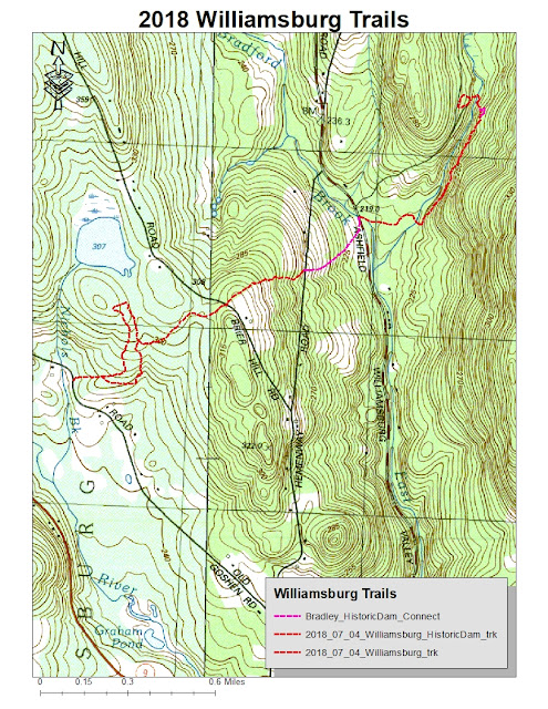
It's still very hot, but I had until noon for a bit of travel and a run.  I drove to Williamsburg, Massachusetts to explore Williamsburg Woodland Trails "Historic Dam Trail".

The finished product is very nice, and rich in history.  As I read the signage detailing the disaster of 1874, I was reminded of current events with similar stories.  The short version is the dam was not built to original safety specs in order to save money.  The disaster wasn't a surprise.

I enjoyed some time on a snowmobile or old logging path, which I'd used in 2016, but it was grown up a bit, so I bailed.  Ended that portion of my day with 2.7-miles.

Realizing I still had some time (thank God for very early starts), I drove over to Old Goshen Road and the parking area of the Bradley Sanctuary.  I wanted to see if the old snowmobile route was still something I could follow, as it actually used to end up across the street from the trail-head of the Historic Dam Trail.

Managed just fine, up to the road crossing at Briar Hill Road, and then to the next at Hemenway Road.  The next short section, through one field, a skip through some woods, and then the final field along Ashfield Road, hadn't been mowed so I avoided.  The old connectors are still intact.

Added 3.6-miles on this portion, so 6.3-miles for the day.  Description below is from the Williamsburg Woodland Trails site.


Historic Dam Trail​

On May 16, 1874, The Mill River Flood disaster claimed 139 lives and devastated the villages of Williamsburg, Skinnnerville, Haydenville and Leeds. The flood resulted from the failure of a dam which had been constructed by local mill owners three miles north of the Village of Williamsburg. The 600 million gallons of water that burst from the dam destroyed dozens of mills and houses and changed the appearance and the course of our town's history forever.

The ruins of the dam still exist today in the woods north of Williamsburg, but until now there has been no access to the site for the general public. Adjacent landowners and the Northampton Water Department (which owns the site of the ruins) have collaborated with the Trails Committee to develop a new pedestrian trail from Ashfield Road to the Dam ruins. The trail tells the story of the Flood and also the 250 year history of the Hemenway family farm and forest management in the Hilltowns.

As of Spring 2018 the new trail is complete! There are three footbridges, several plank bridges, a kiosk, benches, interpretive signs and trail tread improvements.

Tuesday, July 3, 2018

Continuing to track my "peaks", or at least "high points" along the trails I cover.

June's High Points:
  • West Sufffield Mountain, Suffield, CT
  • High Ridge, Williamsburg, MA
  • Orchard Hill, Goodwin Race, CT
  • Parker Hill, Dubuque State Forest, Hawlaey, MA
  • Lake McDonough Lookout I, New Hartford, CT
  • Lake McDOnough Lookout II, Barkhamsted, CT
  • Sunset Lookout, Barkhamsted, CT
  • The Pinnacle, Penwood State Forest, CT
  • Little Thumper Mtn, Mohawk Trail State Forest, Charlemont, MA
  • Thumper Mtn, Mohawk Trail State Forest, Charlemont, MA
  • Indian Path to Saddle between Clark & Todd, Mohawk Trail SF, Charlemont, MA
  • Clark Mountain, Mohawk Trail State Forest, Florida, MA
  • Todd Mountain, Mohawk Trail State Forest, Charlemont, MA
  • "Nick's Hill", West Suffield Mountain / Metacomet Ridge
  • Hampden Overlook, Hampden, MA
  • Goat Rock, Hampden, MA
  • Minnechoag Mountain, Hampden, MA
  • Hill 880' (Bald Mtn, Hampden), Hampden, MA
  • Pine Mountain, Hampden, MA
  • Rattlesnake Hill, Hampden, MA + Somers, CT
  • Perkins Mountain, Camp Ayapo, Somers, CT
  • The Pinnacle, Shenipsit State Forest, Somers, CT
  • Bald Mountain (Somers), Shenipsit State Forest, Somers, CT
  • Peak / Copper Mountain, Metacomet Trail, East Granby, CT
  • Moore Hill, DAR State Forest, Goshen, MA
May's High Points:
  • "Nick's Hill", West Suffield Mountain / Metacomet Ridge
  • West Suffield Mountain, Metacomet Trail, Suffield, CT
  • Copper - Peak Mountain, Metacomet Trail, Granby, CT
  • Stony Hill, McLean Refuge, Granby, CT
  • Pine Mountain, Tunxis Trail, Barkhamsted, CT
  • Indian Council Caves, Tunxis Trail, Barkhamsted, CT
  • Monks Mound, Cahokia Mounds State Historic Site, Collinsville, IL
  • Trillium Hill, Tunxis Trail, East Hartland, CT
  • North Peak, Tunxis Trail, East Hartland, CT
April's High Points:
  • Stony Hill, McLean Refuge, Granby, CT
  • "Nick's Hill", West Suffield Mountain / Metacomet Ridge
  • Bartlett Tower Hill, Tariffville, CT
  • Pinnacle, Penwood State Forest, Bloomfield, CT
  • Skyline Overlook, Somers, CT
  • Rattlesnake Hill, Somers, CT
  • Minnechoag Mountain, Hampden, CT
  • Copper - Peak Mountain, Metacomet Trail, East Granby, CT
  • Hart's Pond Hill, Agawam, MA
March's High Points:
  • Hatchet Hill, Granby, CT
  • "Nick's Hill", West Suffield Mountain / Metacomet Ridge
  • West Suffield Mountain, Metacomet Trail, Suffield, CT
  • Perkins Mountain, Somers, CT
  • Skyline Overlook, Somers, CT
  • Rattlesnake Hill, Somers, CT
  • Minnechoag Mountain, Hampden, CT
  • Stony Hill, McLean Refuge, Granby, CT
February's High Points:
  • Skyline Overlook, Somers, CT
  • Goat Rock and Lookout Point, Hampden, MA
  • Minnechoag Mountain, Hampden, CT
  • "Nick's Hill", West Suffield Mountain / Metacomet Ridge, Suffield, CT
  • Hill 880', Hampden, MA
  • Pine Mountain, Hampden, MA
  • Perkins Mountain, Somers, CT
  • West Ridge, DAR State Forest, Goshen, MA
  • Walnut Hill, Williamsburg, MA
  • Copper - Peak Mountain, Metacomet Trail, Granby, CT
  • West Suffield Mountain, Metacomet Trail, Suffield, CT
  • Merritts Hill, Williamsburg, MA
January's High Points:
  • "Nick's Hill", West Suffield Mountain / Metacomet Ridge
  • Bald Mountain, Shenipsit State Forest
  • The Pinnacle, Shenipsit State Forest
  • "Balanced Rock Hill",  Shenipsit State Forest
  • "Bent Birch Hill", Shenipsit State Forest

Monday, July 2, 2018

I've completed the half-way point of the year according to my calendar, the 26th-week.  I had originally set a goal of 1218-miles for the year, and a half-way point of 588-miles.  I have completed a total of 530.3-miles, which isn't too bad.

I need to continue on my strong showing the past 5-weeks.  Hopefully, building a bit more distance and adding some speed as well.  A marathon attempt seems likely.  All in all, the first part of 2018 has been pretty good...  I just had some setbacks that knocked me off course for a bit.

Sunday, July 1, 2018

We are in the third day of upper 90's for temperature, and this was the first morning where the night didn't seem to cool things off at all.  It looks as though the next 5-days might be similar.

I didn't feel like driving too far, so I settled on McLean Refuge.  I thought it would be slightly cooler in the woods, but I'm not sure it was.  I felt decent for the first 2-miles, but I ended with 6.4-miles for the day, so a chunk of the running was a struggle.

On the positive side, it really can't get much hotter, and today was pretty humid as well.  Once things cool back off, I should feel fantastic while running.  Another positive was this was my fifth week in a row of 30-miles of running.  That is something to feel good about, especially considering the pieces of March and April I had.  I am building consistency.

It wasn't too hot for this guy today

Stony Hill

Saturday, June 30, 2018

An early trip to the Daughter's of American Revolution (DAR) State Forest in Goshen, Massachusetts to verify at least one trail I haven't been on.  The run began on a great note as a small fox crossed the road just as I started jogging.

I was able to locate the "new" trail fairly easily, and rambled through two that I haven't been on in a while.  All told, despite the warmth, I managed 10-miles on my legs.

At the end of my route, I re-visited the Lah-Zee Trail, which I first explored on December 3rd, 2017.  Still a good connector, but at the end of running 10-miles, the rocky section in the middle wasn't fun.

As I exited the trail onto the paved road, I was met by a pair of adult geese with four of their young.  They were not going to budge, so I made the wide path around them.  

Pool off Wing Hill Road

Impressive Stonewall running west on the Oak Hill Connector

Impressive Stonewall running east on the Oak Hill Connector

DAR's Balanced Rock

DAR's Balanced Rock

DAR's Balanced Rock

DAR's Balanced Rock

Beech Tree as expression of thoughts, along the Long Trail

Mass of Fern along Moose Run

Firetower at Moore Hill

Geese at my finish

Places to be as well


Also, on this day in 2006, I completed my 33rd marathon, Tunxis II.  This was the second time in 5-weeks that I marathoned along the Tunxis Trail...  this time, I used the southern portion down to Satan's Kingdom.  My time was 6:06:30, and I had Tippi along for company.  It was her 9th completed marathon.

Tippi on top of  Indian Council Caves, along the Tunxis.
 

Friday, June 29, 2018

Somewhat hot today, but I got out early enough that it wasn't a burden.  Rolled through the 8-mile run along the Metacomet, from Phelps Road to Copper Mountain, and back.  I was very slow, but comfortable.  It just wasn't a day for running too hard, I guess.

I was able to grab photos of the leaves from what I believed was a Chestnut Oak (which are plentiful along the ridge).  The leaves confirmed what I thought was a Chestnut Oak, was.

Chestnut Oak Leaf

Chestnut Oak

Chestnut Oak Leaf on ground

Old Metacomet Trail button (on a Chestnut Oak)

George A. Harmon Woodlot (Suffield Land Conservancy Property)