Saturday, September 11, 2021

I am back on a Granville kick, basically the Drake Mountain Area.

Explored some additional trails and finished with 9.6-miles.

Large Split Rocks "a passageway"

Huge 15' - 20' Boulder, possibly perched, flying American Flag

Huge 15' - 20' Boulder, possibly perched, flying American Flag

Huge 15' - 20' Boulder, possibly perched, flying American Flag

View from Huge 15' - 20' Boulder, Holyoke Range in distance

A second Huge 15' Boulder

A second Huge 15' Boulder

Friday, September 10, 2021

Drove out to Granville after work to re-check and run the mountain-bike path I stumbled onto back on May 21st.

Completed 6.2-miles and witnessed a perfect balanced rock I had not noticed before.

Balanced - Perched Rock

Balanced - Perched Rock

Balanced - Perched Rock

Larger Balanced - Perched Rock

Larger Balanced - Perched Rock

From the Archives:  On this day in 2007, Tippi and I finished the Notchview Marathon.  We ran from Notchview Reservation in Windsor, Massachusetts into Dubuque State Forest in Hawley, then to Savoy Mountain State Forest in Savoy.  We got crushed by a heavy rainstorm for the last 3-miles.

This was my 37th completed marathon, and Tippi's 11th.  All in all, I was not in fantastic shape but the year was winding down, and the run was incredibly enjoyable.  Missing a turn shortly after Windsor Jambs, continuing on the dirt road for a bit, didn't count as a positive.

Looking at the map, we passed Windsor Pond, Crooked Neck Pond, and Hallockville Pond along the journey.  

Meadow at Notchview 

Tippi on the Jambs Trail.

Windsor Jambs.

Alert, as always.

Jambs, with Tippi on the ledge, upper right,


Weekly Weigh In while involved with the 61-Day Challenge - 223 lbs.

Thursday, September 9, 2021

What Played in Ed's Head -- Music listened to for the time-period  August 1st through 31st, 2021:

Wednesday, September 8, 2021

"High Points" along trails during August, 2021... (fractured left toe still a bit of an issue)

  • "East" Bad Luck Mountain, Granville, Massachusetts.
  • "West" Bad Luck Mountain, Granville, Massachusetts.
  • "East" Sweetman Mountain, Granville, Massachusetts.
  • Stony Hill, Mclean Refuge, Granby, Connecticut
  • Day Mountain, Appalachian Trail, Hinsdale, Massachusetts
  • Sweetman Mountain, Granville, Massachusetts.

Tuesday, September 7, 2021

A couple of Blast from the past, retelling from the Archives:  Curly's Marathon was held in Pittsfield State Forest on this day in 2008, and it was a beautiful day to run.  I made the mistake of wearing old shoes rather than a new pair I had just purchased, and it was a very poor decision. 

The pain in my feet and lower legs was incredible for the last 6 or 8 miles, and I was lucky to finish in 5:54:36.  

This was my 40th completed marathon.  My dad ran the Half-Marathon option as well.

Additionally, More from the Archives:  

Dunbar - Whitcomb - Jambs Marathon for Wuzzam and I on this day in 2014.


Wuzzam and I conquered Dunbar-Whitcomb-Jambs in 6:21:34.  This expanded from an old run the Bandit and I did on a few occasions, from Whitcomb Summit to Windsor Jambs.

This time, we began at Dunbar Brook in Monroe State Forest, and ventured out a new snowmobile trail to the windmills to Whitcomb Summit, over Crum Hill, over Flat Rock Hill and the old Viewing Platform for the Hoosac Tunnel, crossed the Cold River on an obscure grown in path, past Savoy Mountain State Forest at North Pond, past Bog Pond, over Lewis Hill and Borden Mountain, through Windsor Bush into Windsor State Forest and the Jambs.

Outstanding day with outstanding sunny weather.  This was my 54th completed marathon. 

 Unfortunate Windmill site.

The Elk Monument at Whitcomb Summitt.

Viewing Platform for the Hoosac Tunnel construction.

View from Flat Rock Hill with Greylock in view.
 

Crossing of the Cold River.

Stone Carving on rock, obscure path.

Bog Pond.

The Dunham Lot, off Tannery Road.

We are getting close!

The Jambs!

Dwarf Forest and the softest ground-cover imaginable.


Monday, September 6, 2021

McLean with K2, after getting lost finding the start line at Shenipsit.

Completed 5.2-miles total (with the first 4-mile loop in 44:34).

Sunday, September 5, 2021

Bear Hole visit, ran hard covering the 5.4-mile adjusted race course (54:04).

Saturday, September 4, 2021

It was a beautiful cool day (low seventies) to take another tackle at my Massachusetts Appalachian Trail Adventure.  I last ended up on Gulf Road in Dalton, where the AT and the BNRC Boulder's Property converge.  My goal would be to connect from this point through to Cheshire, at the Ashuwillticook Rail Trail Parking area.  I completed the section from Cheshire at Church Street to Old Adams Road on May 6th of this year previously.

The footing was difficult for much of this section, and it is long as there are no "break points" along the way (road crossings).  It probably wasn't smart to have run the "race-pace" 5km yesterday as well.  Regardless, the run was awesome, with a good climb over North Mountain, a peaceful view of Gore Pond, many flowing, clean brooks to cross, and the outstanding view from the Cheshire Cobbles.

When I arrived at the Ashuwillticook Parking area, I had some serious leg fatigue (I was at mile 7.5).  I figured the distance would be about the same, but I would benefit from the overall "flatness" of running the rail trail back to Gulf Road, and then back to the start through the "Gulf".

This was flat, but I was wearing an older pair of running shoes and the pounding of the asphalt really wore me down.  I haven't been on this section of the Ashuwillticook since a 10-mile race with the Hillbilly and my Pop long ago.  

Once finished, I had 14.8-miles in, and all that remains of my Massachusetts Appalachian Trail Adventure is roughly 11-miles, from just below Greylock's Summit to the Vermont Border.

Gore Pond

Cheshire Lake from the Cobbles

View of Mt Greylock Range from the Cobbles

Bottom of the Cobbles

Friday, September 3, 2021

Another attempt at "real" running along the Suffield 5km Course.

This time, cool temperatures assisted with a new "PR", 25:10. 

Times for my Race Against Myself at this location:

  • #1, 2019 - 28:04 (July 2nd, 2019)
  • #2, 2019 - 27:46 (July 9th, 2019)
  • #1, 2021 - 27:00 (June 28th, 2021)
  • #2, 2021 - 25:20 (July 9th, 2021)
  • #3, 2021 - 26:48 (August 20th, 2021)
  • #4, 2021 - 25:29 (August 27th, 2021)
  • #5, 2021 - 25:10 (September 3rd, 2021)

Thursday, September 2, 2021

Continued recovery and repair due to remnants of Hurricane Ida at work;  this weather lately has been a struggle for treating water/wastewater.

Wednesday, September 1, 2021

Long day and night working through remnants of Hurricane Ida, plenty of driving rain forcing us to work overtime protecting public health and safety.

Tuesday, August 31, 2021


It's that time of year again, the beginning of the 61 Day Challenge.

Last year, I extended the duration to 92 Days (October through December).

This year, I am beginning on September 1st!  A 122 Day Challenge!

November 1 - December 31, 2021
The New England 61 Day Challenge is a healthy lifestyle initiative that includes education about healthy eating, physical activity, and positive behavioral changes. It encourages individuals and groups to participate and learn how to make smart choices and develop healthy behaviors.

New England 61 Day Challenge Pledge
Today, I pledge to participate in the New England 61 Day Challenge.
I will make my health a priority and focus on developing and nurturing my body, mind, and spirit.
I will strive to meet the challenge goals of no soda, no sweets, and no cigarettes.
I will remember that there will be bumps along the road, and I'll stay focused for the entire period.
I pledge to learn and grow in knowledge and to make healthier decisions on a daily basis.
I will support my colleagues, friends, and family throughout the Challenge.
I will take what I learned during the Challenge and strive to maintain my new healthy habits.

****  Additional steps we will be working on are:
  •           No Fast Food.
  •           Limited Fried Food.
  •           Limited Bread.
  •           No Alcohol.
  •           Exercise regularly.
  •           Drink 64 ounces of water daily.
This is my fourth consecutive year with this program, and once again I am determined to have a great four-months working toward success.

And, Marathon History today...
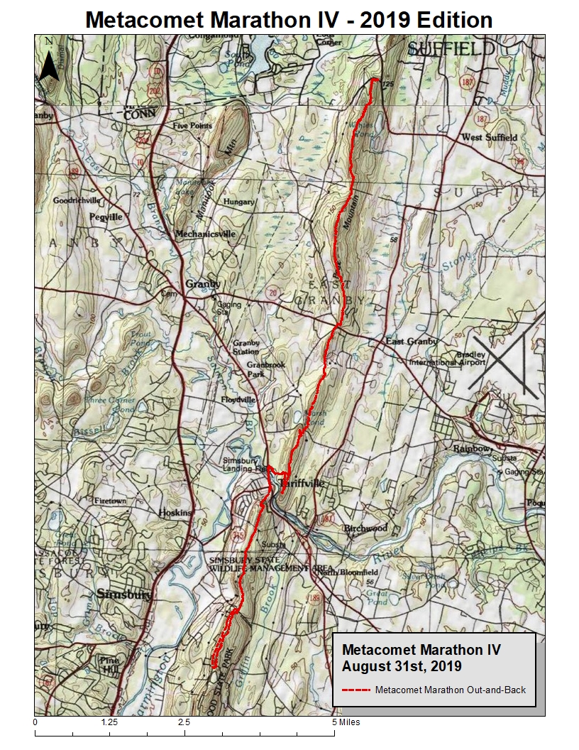
Metacomet Trail Marathon - August 31st, 2019
West Suffield, East Granby, Bloomfield & Simsbury, CT

Today would be the day I would try my first Marathon distance run since 2014.  I am not as fit as I would have liked, as I am carrying 15 or so extra pounds.  I haven't really done any racing in many years, so running hard hasn't happened either.  It has been a struggle health-wise at times, with constant issues related to the bouts with Lyme Disease, as well as the entire repair from the brain tumor surgery.  Basically, I have grown tired of trying to get into "perfect" shape to attempt this distance, as it's dawned on me that "perfect" shape may never materialize.  So, today is the day to suffer if need be.

The original route was the Granville State Forest to Satan's Kingdom using Granville, MDC Forest Roads, and the Tunxis Trail that I had worked out through exploration and mapping during the past few years.  But, that would need two vehicles or a shuttle, and Wuzzam wasn't recovered from the McLean distance last Saturday.  While DL offered to shuttle, I decided to run the Metacomet Marathon that Wuzzam completed with me in 2012.

This would be the fourth Metacomet Marathon I would attempt.  Earlier versions were:

April - 2006, with Tippi.  From Sunrise Park all the way through Penwood completely, and back.  This is actually much further than 26-miles, more in the 28 or 29-mile range.

August - 2008, with Tippi.  From Phelps Road in Suffield, north to Robinson State Park and back for the first 16-miles, and then from Phelps south to Route 20 and back for 10-miles more.

June - 2012, with Wuzzam, and Tippi for the first 10-miles.  This would be the same route as today's scheduled route.  Park at Route 20 in East Granby, run north to Phelps in West Suffield and back for the first 10-miles, and then head 7-miles south into Penwood to do a 2 to 2.5-mile loop before heading back to Route 20 for the last 7-miles, with a grand total of right at 26+.

I got an early enough start, after my one aid-stash at miles 14.5 & 22.  8:50 a.m. I was running along on my way.  Completed the first 10-miles averaging 4.3 mph on the hilly, rocky trail.  All in all, I felt pretty good at that point.

The Hatchet Hill section into Tariffville and the Farmington River became a bit tougher, and by the time I was climbing up toward the Bartlett Chimney around 15-miles, I was feeling a little worn.  Recovery was achieved, and as I approached the Penwood section I was shuffling along pretty well again.

The Metacomet once in Penwood, through to the Pinnacle, is harsh.  Mostly climbing on rocks, with a few lengths of trail to actually run well.  I run this section often enough, and I am able to run it, but that is due to starting at this point, not beginning it at 17-miles.  Today, this section was taken at a fast hiking pace rather than truly running form.

Once on the bottom of the Pinnacle, I feel as though I really charged through the lower section of Penwood back to Wintonbury Road.  My time dipped to an average of 4.1-mph through 22-miles.

The two final legs, from the Farmington River and over Hatchet Hill, was extremely difficult.  For this final 4-miles, I ended up dipping to a 3.9-mph average for the day.  I was still able to jog reasonably well on the more level sections, but the uphills were pushing my heart-rate to a place I wasn't comfortable.

To finish was awesome.  I wasn't sure I had the mental determination to tackle the suffering that a marathon in the woods presents.  I proved to myself that toughness isn't an issue at this point.  My legs were in great shape, I did not have any trouble on the later downhills, even the steep ones.  I am very satisfied with my overall conditioning regarding leg strength.  Even the late uphills, it was more the cardio than the leg muscles.  Limited long trail racing over the past 5-years reared it's head today.

Final thought is I am very satisfied.  In perspective, during the 2012 version on the same route, I had a final total time of 7:01:00.  Today, I ended up at 6:56:00 total, 6:41:00 moving time.  I believe the 2012 run was a much hotter day, as my memory tells me that.  I also think the "stopped" time would have been greater for the older run, but I don't have any data proving that.  So, all in all, a real good run that I can build on.

This was my 55th completed marathon lifetime.

Mile One and Nine, Peak/Copper Mountain

Mile Five, Phelps - Suffield Land Conservancy Property

Mile Eleven, enormous Oak

Mile Thirteen and a half, overlook at T-Ville

Mile Fourteen & Twenty-Two, Farmington River

Mile Fourteen & Twenty-Two, Farmington River

Mile Sixteen & Twenty, Ledge after Bartlett Chimney

Mile Eighteen+ at base of rock stairs to Pinnacle